<?xml version="1.0" encoding="utf-8"?><feed xmlns="http://www.w3.org/2005/Atom" xml:lang="en-GB"><generator uri="https://jekyllrb.com/" version="4.4.1">Jekyll</generator><link href="https://ianrenton.com/feed.xml" rel="self" type="application/atom+xml" /><link href="https://ianrenton.com/" rel="alternate" type="text/html" hreflang="en-GB" /><updated>2026-09-08T18:30:04+00:00</updated><id>https://ianrenton.com/feed.xml</id><title type="html">Ian Renton</title><subtitle>The website of Ian Renton, a software engineer and builder of robots</subtitle><author><name>Ian Renton</name></author><entry><title type="html">The IC-705 Kit</title><link href="https://ianrenton.com/blog/the-ic-705-kit/" rel="alternate" type="text/html" title="The IC-705 Kit" /><published>2026-09-08T00:00:00+00:00</published><updated>2026-09-08T00:00:00+00:00</updated><id>https://ianrenton.com/blog/the-ic-705-kit</id><content type="html" xml:base="https://ianrenton.com/blog/the-ic-705-kit/"><![CDATA[<p>Since I name-dropped my new IC-705 transceiver in <a href="/blog/summers-last-gasp-5th-backpackers-and-isle-of-wight-rove/">my previous post</a>, I thought I’d add another quick post to cover the rest of the kit as well.</p>

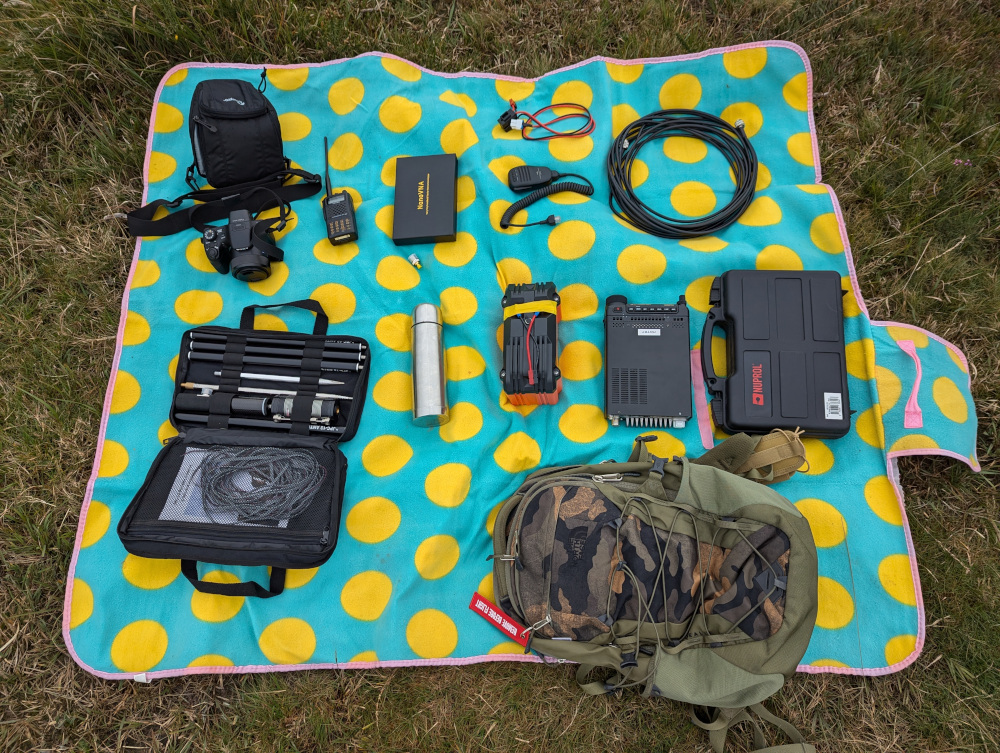
<p><img src="/img/blog/2026/09/705-1.jpg" alt="LowePro DSLR case" class="center" /></p>

<p>I went for <a href="https://www.amazon.co.uk/dp/B0BLZG4SN6">this bag</a> on advice from a SOTA Reflector post, and honestly it could do with being about 20mm wider, as it does feel like it’s pushed into a bit of a trapezium shape by the size of the IC-705. However, it does close up properly, and the clip still properly clips around it, so it does the job.</p>

<p>I have the radio held so that it can be accessed only by opening the top, and further down inside are compartments for my 6Ah LiFePo4 battery (as previously used with the FT-817) and the fist mic. So in order to get on the air, I do have to fully unzip the bag to sort things out before closing it up again.</p>

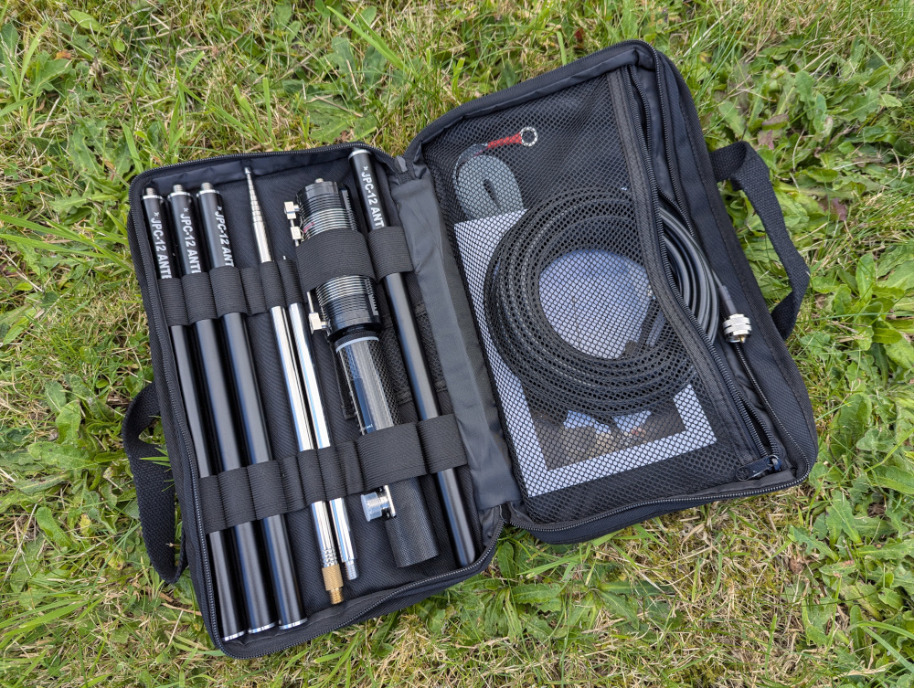
<p><img src="/img/blog/2026/09/705-2.jpg" alt="Case expanded to show the contents" class="center" /></p>

<p>Since space is tight on both the left and right sides, I have used right-angle adapters for both power (DC 5.5x2.5 barrel jack) and coax (BNC). The BNC also has a short extension cable that I can loop through and out of the top. The bag can then sit between my legs while I’m activating, with coax coming out one side, fist mic out the other, and the battery hidden away inside.</p>

<p>I haven’t bothered to protect the front of the radio with a cover. Having it sat in the bag a few centimetres shy of the top seems to do the job well enough, as the bag is quite rigid when closed.</p>

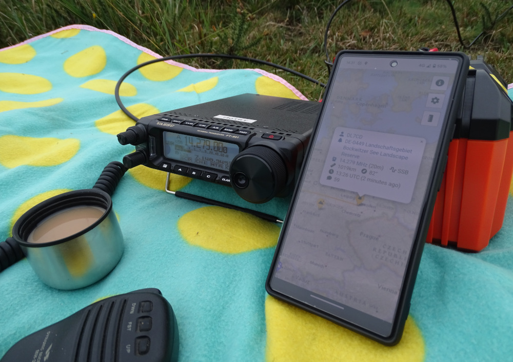
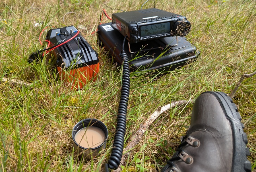
<p><img src="/img/blog/2026/09/705-3.jpg" alt="Radio in use" class="center" /></p>

<p>I did consider both the official Icom LC-192 backpack and the cheaper Windcamp equivalent, but for me they seem to be simultaneously too much and not enough. While they would be fine for a quick walk from the car to a picnic table, they just don’t have enough space for the extra bits an actual hike demands: water bottle, thermos, jumper, coat, etc. But for putting <em>inside a larger bag</em> with all that other stuff, the Icom and Windcamp bags are just too heavy and bulky. So, I settled for something that—while still a little bulky—can happily be chucked into a hiking rucksack with plenty of space left over.</p>

<p>And of course, you can do it up when it rains.</p>

<p><img src="/img/blog/2026/09/705-4.jpg" alt="Bag closed, with coax and fist mic cables entering through a gap in the zips" class="center" /></p>

<p>The speaker in the fist mic makes things even better here; I think this is the first radio I’ve owned with that feature. Now with the whole thing buttoned up, even operated from inside the rucksack for extra waterproofing, I can still hear what’s going on clearly. It’s helpful to be able to hold it up to my ear when I’m feeling deaf as well!</p>

<p>I can’t lie, this wasn’t a cheap purchase. However, the VHF contest experience was much easier than with the FT-817, and I had fun with it QRP on the HF bands as well. There’s a definite chance this will end up being my “middleweight” kit from now on (compared to the heavyweight FT-891 + 20Ah battery, or the lightweight QMX + USB power bank) and the FT-817 and X6100 will end up getting sold on.</p>

<p>Now that I’ve completed <a href="/blog/2026-challenge-complete-activate-all-pota-parks-within-20-miles/">that damn challenge</a> I’m thinking much more about taking it easy on the radio, running QRP, with more focus on enjoying myself in the countryside and less on caring if it’s a “successful” activation. For that purpose, the new kit seems ideal.</p>

<p>It’s got a lot of catching up to do, to match the QSOs-per-pound value of the 891, but fingers crossed with a few more years of more relaxed outdoor radio operating, it’ll get there.</p>]]></content><author><name>Ian Renton</name></author><category term="blog" /><category term="ham-radio" /><category term="radio" /><category term="amateur-radio" /><category term="kit" /><summary type="html"><![CDATA[Shameless kitposting]]></summary><media:thumbnail xmlns:media="http://search.yahoo.com/mrss/" url="https://ianrenton.com/img/blog/2026/09/705-3.jpg" /><media:content medium="image" url="https://ianrenton.com/img/blog/2026/09/705-3.jpg" xmlns:media="http://search.yahoo.com/mrss/" /></entry><entry><title type="html">Summer’s Last Gasp: 5th Backpackers and an Isle of Wight Rove</title><link href="https://ianrenton.com/blog/summers-last-gasp-5th-backpackers-and-isle-of-wight-rove/" rel="alternate" type="text/html" title="Summer’s Last Gasp: 5th Backpackers and an Isle of Wight Rove" /><published>2026-09-06T00:00:00+00:00</published><updated>2026-09-06T00:00:00+00:00</updated><id>https://ianrenton.com/blog/summers-last-gasp-5th-backpackers-and-isle-of-wight-rove</id><content type="html" xml:base="https://ianrenton.com/blog/summers-last-gasp-5th-backpackers-and-isle-of-wight-rove/"><![CDATA[<p>With the fifth and final RSGB Backpackers contest coming up, I fancied a try at a new hilltop, and with it one of my last chances to get some more 2m SSB contacts in the log for the 2026 SOTA challenge. The logging assistant decided to cycle around the island on the Isle of Wight Randonnee, so I headed over with him, and took the opportunity to hit up the local SOTA summits.</p>

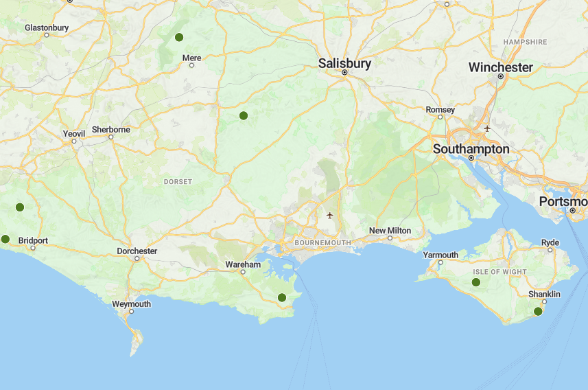
<p>The island has only two: <a href="https://sotl.as/summits/G/SE-012">G/SE-012 Brighstone Down</a> and <a href="https://sotl.as/summits/G/SE-008">G/SE-008 St Boniface Down</a>. The latter has bags of open space, while the former is completely wooded, so St Boniface was the obvious spot for the contest itself. But since we’d come over on the 0650Z ferry, I had plenty of time to spare before the 1000Z contest start, and decided to hit up Brighstone first.</p>

<h2 id="0845-0900z-brighstone-down">0845-0900Z: Brighstone Down</h2>

<p><img src="/img/blog/2026/09/iow-1.jpg" alt="View south over the sea from the path up Brighstone Down" class="center" /></p>

<p>I parked in <a href="https://maps.app.goo.gl/4wM3yjP7AUAGs37K8">Jubilee car park</a>, from which it was a short and easy ascent up the side of the hill, pausing for a chat with the farmer on the way. The path then turns north into the trees, and walkers will need to pick their route carefully if they want to find the trig point—it is where the peak is shown on OpenStreetMap, but it’s well off the track and the overgrown path to it is not easy to spot. The trig point itself has precious little antenna space, so I set up in a clearing in the woods nearby. Equipment for this activation was my new IC-705, 6Ah battery, and JPC-12 vertical.</p>

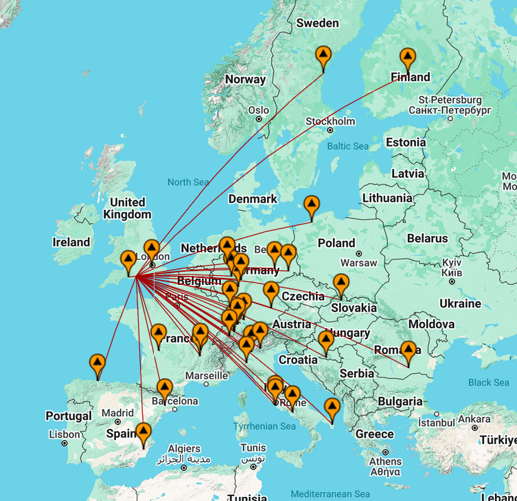
<p>Bringing the JPC-12 was a good choice, as while the forest was probably sparse enough that I could manage the 40m dipole, it wasn’t worth the risk of getting it tangled and stuck. I went for the 20m band, which was running very long at that time of the morning, and so with only 10 Watts to play with it was a slow start. My contacts ranged from Austria to Finland.</p>

<p><img src="/img/blog/2026/09/iow-2.jpg" alt="JPC-12 vertical in the woods" class="center" /></p>

<p>With five in the log after fifteen minutes, I decided to pack up and head out. Despite it being a relatively quick walk from the car park to the summit, time was still ticking on and I had yet to buy my lunch, meaning I was likely to miss the start of the contest already.</p>

<h2 id="1100-1400z-st-boniface-down-backpackers-contest">1100-1400Z: St Boniface Down (Backpackers Contest)</h2>

<p>By the time I’d navigated the island’s winding roads and scores of cyclists, found a space in the car park atop St Boniface down, found an activation spot, realised I’d forgotten my antenna and gone back to the car, returned to my spot, then set up, it was 1100Z (1200 local time). I’d not just missed a small part of the contest but a whole hour.</p>

<p><img src="/img/blog/2026/09/iow-3.jpg" alt="View of Culver Down over the water from St Boniface Down" class="center" /></p>

<p>I picked a spot at the east end of the down, having plenty of space to play with. Thanks to a <a href="https://sotl.as/map/coordinates/50.607068,-1.198895/14.1">new Sotl.as feature</a> which shows the extent of the 25m altitude activation zone, I knew I had my pick of spots just about anywhere, and chose what looked like the highest and most out-of-the-way place I could.</p>

<p>For the contest I continued using the IC-705, which with its waterfall display and pre-recorded voice messages proved a huge improvement over the FT-817 I’d used for the previous Backpackers. I was intending to keep using the FT-817 for a good while, until VHF Field Day with the club made me realise how nice having a waterfall was when contesting. Now I think the poor old 817 might be getting sold before long…</p>

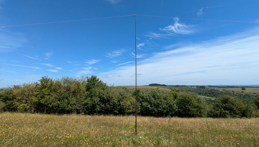
<p>On the antenna side, my Arrow 4-element Yagi returned to service, along with the 5m pole I had bought ahead of <a href="/blog/145-alive-at-win-green/">the last 145 Alive</a>. I left the 6Ah battery disconnected, trusting the internal battery in the IC-705 to deliver the 5W I was limited to in the contest.</p>

<p><img src="/img/blog/2026/09/iow-4.jpg" alt="Yagi antenna on a pole, viewed from below" class="center" /></p>

<p>Yet again I was dishing out serial numbers far lower than most of my QSO partners, even most of the backpackers, so there’s a very strong chance I’ll end up coming last again. However, my 33 contacts was a definite improvement on the 16 I managed <a href="/blog/rsgb-2nd-144mhz-backpackers-2026-contest-report/">last time</a>, probably thanks to the pole more than anything else.</p>

<p>A sunny start to the contest turned overcast, but the rain held off bar a few occasional spots, the wind stayed light and the temperature stayed warm. It still felt like summer for a while up on the hill, but I’m sure this will be one of the last activations of the year that I do carefree in a t-shirt, before thoughts turn to jumpers and coats as autumn blows in from the sea.</p>

<p>A number of stations described Scotland as booming in to them, but sadly they weren’t to me. However, being right on the south coast with a clear shot over the Channel was its own advantage, and I was able to work a number of European stations. My best DX of the contest was TM3A in grid square JN36bp, a distance of 432 miles.</p>

<p>By getting 33 in the log on 2m SSB here, I’d also more than doubled my points for the <a href="https://www.sotadata.org.uk/en/challenges/1st270Activator">2026 SOTA challenge</a>. Having missed three out of five Backpackers, been bumped off a summit once and had technical issues with the FT-817, I’d not had many opportunities to get points towards this challenge, and today could well have been my last big opportunity.</p>

<h2 id="1430-1500z-st-boniface-down-bonus-activation">1430-1500Z: St Boniface Down (Bonus Activation)</h2>

<p>I’d promised Raph F4LUB that I’d try 40m after the VHF contest was done, so I headed back to the car to swap equipment, and paid a visit to the other end of the hill to bag a bunker, B/G-1181 Ventnor ROTOR Radar site, which I assume is this odd triangular building.</p>

<p><img src="/img/blog/2026/09/iow-5.jpg" alt="Ruins of an old brick building" class="center" /></p>

<p>I only had 20 minutes or so on the air here before I had to leave and pick up my very tired cyclist (in the pub, of course), so 15 QSOs was the total here. It was nice being able to use a spotting service again after the contest which didn’t allow them, and go back up to 10W with the external battery. In relatively short order I worked a number of regulars including a couple of park-to-parks and a bunker-to-bunker.</p>

<p><img src="/img/blog/2026/09/iow-6.jpg" alt="Inverted V dipole antenna with a view over downland" class="center" /></p>

<h2 id="1715-1800z-the-needles">1715-1800Z: The Needles</h2>

<p>After a long cycle and a pint in my son’s case, and three activations already done in mine, it would have been tempting to head for the ferry and home. But having a car on the Isle of Wight was a rare opportunity not to be passed up—I think this was actually my first time driving on the island. We could go wherever we wanted, and have a quick walk to stretch tired legs along with one last chance to hop on the radio.</p>

<p>The ferry schedule prevented a walk along Tennyson Down, but we instead walked up and over the Needles headland and just onto West High Down. I’d requested B/G-2836 High Down Rocket Test Site be added to Bunkers on the Air after <a href="/blog/activation-report-afton-marsh-and-the-needles/">our last Isle of Wight rove</a>, so it was high time we headed back and activated it.</p>

<p><img src="/img/blog/2026/09/iow-7.jpg" alt="Inverted V dipole antenna held up by logging assistant, staring off to Alum Bay in the distance" class="center" /></p>

<p>I was a little worried about whether we’d make it to Bunkers’ 25 QSO requirement, given we had only 10 Watts at our disposal and the 40m band was getting steadily more crowded as evening wore on. However, I needn’t have worried. With the ability to self-spot, setting up next to the Coast Path at the Needles provides a POTA 5-fer, along with three bunkers, a WWFF park, a castle and of course the lighthouse. Once we’d found ourselves a free spot on the band, the QSOs came thick and fast, and we had another 28 in the log before it was time to pack down and head home.</p>

<p><img src="/img/blog/2026/09/iow-8.jpg" alt="The Needles at sunset" class="center" /></p>

<p>81 QSOs was the total for the day, across 6 POTA parks, 2 WWFF, 4 bunkers, and the rest. It’s not an impressive achievement, but I can finally say I’ve activated every SOTA summit on the Isle of Wight as well as Dorset, so new summits to activate are going to involve going significantly further afield. Total time for the rove today was just over 9 hours, with around three and a half of them operating, and one spent in the pub!</p>

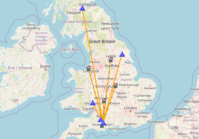
<p><img src="/img/blog/2026/09/iow-map.png" alt="Activation map" class="center" /></p>

<p>Thanks to all my contacts today, and especially those who helped me reach a new high for the Backpackers contests. Catch you on the air on the next time!</p>]]></content><author><name>Ian Renton</name></author><category term="blog" /><category term="ham-radio" /><category term="radio" /><category term="amateur-radio" /><category term="pota" /><category term="sota" /><category term="backpackers" /><category term="contest" /><summary type="html"><![CDATA[Another couple of hill tops in the log]]></summary><media:thumbnail xmlns:media="http://search.yahoo.com/mrss/" url="https://ianrenton.com/img/blog/2026/09/iow-8-small.jpg" /><media:content medium="image" url="https://ianrenton.com/img/blog/2026/09/iow-8-small.jpg" xmlns:media="http://search.yahoo.com/mrss/" /></entry><entry><title type="html">SOTA Activation Report: Autumn on Lewesdon Hill</title><link href="https://ianrenton.com/blog/sota-activation-report-autumn-on-lewesdon-hill/" rel="alternate" type="text/html" title="SOTA Activation Report: Autumn on Lewesdon Hill" /><published>2026-09-02T00:00:00+00:00</published><updated>2026-09-02T00:00:00+00:00</updated><id>https://ianrenton.com/blog/sota-activation-report-autumn-on-lewesdon-hill</id><content type="html" xml:base="https://ianrenton.com/blog/sota-activation-report-autumn-on-lewesdon-hill/"><![CDATA[<p>Once again, summer has been a quiet season for me on the radio. <a href="/blog/2026-challenge-complete-activate-all-pota-parks-within-20-miles/">Completing my POTA challenge</a> made me think I should have a break from HF for a bit, but even on VHF I’ve only been out three times since: Field Day, 145 Alive, and a bonus trip up Nine Barrow Down in July. In August, the only time I used amateur radio at all was for comms between the team at Hamfest.</p>

<p>But time has passed, and the seasons turn once again. Down by the coast the memory of summer lives on, but up on Lewesdon Hill today, autumn was in full swing.</p>

<p><img src="/img/blog/2026/09/lewesdon-1.jpg" alt="Trees in the mist" class="center" /></p>

<p>A day trip to Devon and back provided the opportunity to head to this spot, the last of Dorset’s three SOTA summits that I had never activated. A strong wind whistling through the trees, all-encompassing fog and about 50m visibility made this an eerie one as well as a cold and damp one. I’ve <a href="/blog/purbeck-pota-rove/">activated the Shire</a> before, but the steep wooded path leading up to Lewesdon Hill had a distinctly more Mirkwood vibe.</p>

<p>Despite our driest summer on record having only just ended, the way up was already damp and slippery, and I can well imagine that at any other time of year it will be a mudbath. In places, tree roots mercifully provide steps and grip, but this is definitely a hike you’ll want your boots for. Of course, we did it in trainers and jeans, because we are idiots.</p>

<p>Atop the hill there is plenty of antenna space, and with no-one else braving the weather to climb the hill today, we were for a moment the highest people in Dorset, stood atop its tallest peak.</p>

<p><img src="/img/blog/2026/09/lewesdon-2.jpg" alt="Trees in the mist" class="center" /></p>

<p>We set up the inverted-V dipole for the 40m band, using my FT-891 at 100W powered from a 20Ah battery. Along with the camp chair, it’s around 8kg of kit—although the hill is steep, the walk up from Coombe Lane is less than a kilometre, so the pack weight didn’t cause us any trouble.</p>

<p>I had a few chatty QSOs before self-spotting, after which the pile-up came fast. It was a packed band, and I had occasional trouble trying to work out if I was the only station on frequency or whether there was another, with other people calling them. I also got crowded out by an S9+20 signal 1kHz down towards the end of the activation.</p>

<p>After half an hour and 24 in the log, the antenna was flapping in the rising winds, and fog was starting to soak us and our equipment alike. It never feels good to leave a pile-up in progress, but I decided to call it quits at that point, and start the slippery hike back down the hill towards home.</p>

<p><img src="/img/blog/2026/09/lewesdon-map.png" alt="Activation map" class="center" /></p>

<p>Thanks to all my contacts today, and sorry to those of you who waited patiently in the pile-up and I didn’t make it to. Hopefully I’ll catch you on the air on the next summit.</p>]]></content><author><name>Ian Renton</name></author><category term="blog" /><category term="ham-radio" /><category term="radio" /><category term="amateur-radio" /><category term="pota" /><category term="sota" /><summary type="html"><![CDATA[An activation with our heads in the clouds]]></summary><media:thumbnail xmlns:media="http://search.yahoo.com/mrss/" url="https://ianrenton.com/img/blog/2026/09/lewesdon-small.jpg" /><media:content medium="image" url="https://ianrenton.com/img/blog/2026/09/lewesdon-small.jpg" xmlns:media="http://search.yahoo.com/mrss/" /></entry><entry><title type="html">145 Alive at Win Green</title><link href="https://ianrenton.com/blog/145-alive-at-win-green/" rel="alternate" type="text/html" title="145 Alive at Win Green" /><published>2026-07-12T00:00:00+00:00</published><updated>2026-07-12T00:00:00+00:00</updated><id>https://ianrenton.com/blog/145-alive-at-win-green</id><content type="html" xml:base="https://ianrenton.com/blog/145-alive-at-win-green/"><![CDATA[<p>For this afternoon’s <a href="https://www.145alive.com">145 Alive</a> event, I took a gamble and headed to every local ham’s favourite spot, Win Green. I had backup plans in case the summit was already spoken for, but luckily (and I think for the first time) I didn’t see another ham all day, and had the hill entirely to myself. Apart from a few interested walkers, ex-CBers and a couple of excitable dogs, anyway.</p>

<p><img src="/img/blog/2026/07/145alive-1.jpg" alt="4 element Yagi antenna on a 5 metre pole, surrounded by dry grass. Hills in the background and a blue sky." class="center" /></p>

<p>In the month that had passed since <a href="/blog/rsgb-2nd-144mhz-backpackers-2026-contest-report/">my first Backpackers contest</a>, I had invested in a 5m telescopic aluminium pole, to hopefully alleviate the frustrations caused by my short and top-heavy camera tripod. 145 Alive from an easy drive-up SOTA summit gave me the perfect opportunity to test it out, and the good news is that despite some hairy 20-25 knot gusts and dubious guy rope pegging in the dry soil, it behaved itself perfectly well.</p>

<p>The same couldn’t be said for the bands, at least in my location. After spending the first half of the event on the FM net run by G3EC at the Royal Signals, I switched over to work M9WWA’s SSB net from Westbury White Horse. Unfortunately I had S7-8 noise right across the SSB portion of the band again, and unlike during the Backpackers contest, it didn’t seem to shift. I made a total of two QSOs on SSB, then went back to the FM net.</p>

<p>Things weren’t perfect there either, as GB1ALV was running a net on the Hog’s Back in Surrey on the same frequency. That meant any time I beamed my antenna east (or west, to some extent) I could hear bits of their net mixed up with ours. However, all in all I managed 17 QSOs on the FM net, including M9SEB, M7GET and (with significant help from the net controller) Paul G7EWY.</p>

<p><img src="/img/blog/2026/07/145alive-2.jpg" alt="FT-817 in a bag" class="center" /></p>

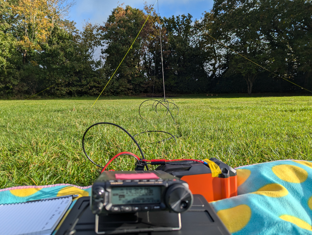
<p>Equipment was as usual apart from the new pole: FT-817nd running 5W, and my Arrow Yagi antenna with just the four 2m elements fitted.</p>

<p>We are well over six months into the year, and with those two SSB QSOs, I am at least <em>finally</em> on the SOTA <a href="https://www.sotadata.org.uk/en/challenges/1st270Activator">2026 2m/70cm SSB/CW scoreboard</a>. Admittedly I’m in 47th place, but hey, at least I’m there at last, and more opportunities await over the coming months.</p>

<p>My best DX of the day was with David M0KYN, who despite being a local, joined the net from IO82ka in the Black Mountains, a distance of 135km. I had my fingers crossed for some French or Belgian stations joining the nets based on the tropo forecast, but sadly it wasn’t to be—though if anyone joined the SSB net from far afield, I doubt I would have heard them anyway in those conditions!</p>

<p><img src="/img/blog/2026/07/145alive-map.png" alt="4QSO map" class="center" /></p>

<p>Thanks to everyone who spoke to me in the nets today, especially net controllers G2EC and M9WWA. Catch you on the air again next time!</p>]]></content><author><name>Ian Renton</name></author><category term="blog" /><category term="ham-radio" /><category term="radio" /><category term="amateur-radio" /><category term="145-alive" /><summary type="html"><![CDATA[The only Ham on the Hill, for the first time ever]]></summary><media:thumbnail xmlns:media="http://search.yahoo.com/mrss/" url="https://ianrenton.com/img/blog/2026/07/145alive-small.jpg" /><media:content medium="image" url="https://ianrenton.com/img/blog/2026/07/145alive-small.jpg" xmlns:media="http://search.yahoo.com/mrss/" /></entry><entry><title type="html">2026 Challenge Complete: Activate all POTA Parks within 20 miles!</title><link href="https://ianrenton.com/blog/2026-challenge-complete-activate-all-pota-parks-within-20-miles/" rel="alternate" type="text/html" title="2026 Challenge Complete: Activate all POTA Parks within 20 miles!" /><published>2026-07-03T00:00:00+00:00</published><updated>2026-07-03T00:00:00+00:00</updated><id>https://ianrenton.com/blog/2026-challenge-complete-activate-all-pota-parks-within-20-miles</id><content type="html" xml:base="https://ianrenton.com/blog/2026-challenge-complete-activate-all-pota-parks-within-20-miles/"><![CDATA[<p>It’s been a busy two years.</p>

<p>In June 2024, after four years holding an amateur radio licence without talking to anyone, <a href="/blog/my-first-easiest-and-last-sota/">I finally discovered “my thing”: portable operating</a>. Alongside the thrill of getting on the air and the beauty of being out in the wild, came an obsession with completionism driven by the maps I could now pore over to my heart’s content.</p>

<p>Parks on the Air (POTA) stood out as a programme that was becoming hugely popular, with an abundance of references to activate around my home. Once I’d created the <a href="https://newparks.m0trt.radio/">New Park Finder</a>, that sealed the deal—I could see a forest of red and yellow markers representing adventures yet un-experienced. I had to do them <em>all</em>. As far as is reasonable, anyway. But parks were being added to the system faster than I was working my way though them, leading to me dedicating some serious time to POTA activating.</p>

<p>In spring 2025, a cluster of new markers in Christchurch led to me discovering POTA roves, via <a href="/blog/christchurch-pota-rove-eight-parks-in-eight-hours/">a long and very damp hike</a>. Less than a month later, and several more roves in the log, <a href="/blog/pota-activation-report-st-catherines-hill/">I’d completed all parks in my local council area</a>.</p>

<p>But come autumn, so many more parks had been added to the system that another <a href="/blog/parks-i-dont-wanna-do-tour-2025/">epic five-day rove</a> was required to visit the <em>seventeen</em> new parks in that same area.</p>

<p>By the end of the year, I had <a href="/blog/52-week-ham-radio-challenge-roundup-weeks-49-52/">set myself a goal for 2026</a>: race against the new park additions to activate every POTA park within 20 miles of home.</p>

<p>When I set out, on January 1st, I had 11 parks to go out of 103.</p>

<p>Today, I completed that challenge, activating The Raymond Brown Nature Reserve in Ringwood: the <strong>138th</strong> and final park on the list.</p>

<p><img src="/img/blog/2026/07/raymond-brown.jpg" alt="Raymond Brown Nature Reserve sign" class="center" /></p>

<p>The forecast G2 solar storm didn’t put us off, and in fits and starts, we made it through our 10 QSOs to qualify the activation in 25 minutes, before a quick wander along the trail and home.</p>

<p>Home to upload logs, run the numbers, and generate one all-important screenshot.</p>

<p>And here it is. Every single park within 20 miles is green.</p>

<div class="breakout-full-width"><center><img src="/img/blog/2026/07/all-parks-map.png" alt="POTA New Parks map showing all green markers within a blue circle" style="width:100%" /></center></div>

<p>From Prescombe Down in the north to Durlston head in the south, and from Knighton Reserve in the west to Afton Marsh in the east. It is DONE.</p>

<p>At some point on the <a href="https://w0rmt.net/ffwn/">Fedi Friday Winlink Net</a>, the weekly question was whether you stopped portable operating for the winter. Of course I don’t, but out of interest I decided to plot a chart of POTA activations by month to see what effect winter did have on them. The answer is, it’s largely pretty random, and the chart is dominated by when I chose to do the big roves. If you group the activations by season, my quietest portable operating season seems to be… summer. I guess I have more important things to do and fewer weekends free!</p>

<p><img src="/img/blog/2026/07/parks-by-month.png" alt="Chart of POTA activations by month over the last two years" class="center" /></p>

<p>With the activation of all POTA parks within 20 miles, I’ve also done every SOTA summit in the same distance (not hard—there’s two of them), every lighthouse (three) and every WWFF park as well. But there are still a lot of bunkers, beaches and other portable radio adventures left to experience!</p>

<p>However, having achieved this goal, I am going to put a stop my completionist tendencies here. I’ve regularly moaned about activating the small town parks, particularly the ones popular with tourists; they’re just not what I want from my outdoor radio operating. In satisfying my need to turn all the map markers green, I had to do them anyway—<a href="/blog/parks-i-dont-wanna-do-tour-2025/#lowergardens">and faced my fears in the process</a>—but from this point on I will not force myself to tick off all the red and yellow markers. Others can enjoy those parks in their own way if they want to, but they’re not for me. I’ll also spend more time enjoying parks I’ve visited before, rather than constantly having a nagging feeling that I could be doing a “new one”. There’s so much out there to see, and it shouldn’t matter whether some idiot (me) wrote a program that gives a place a red, yellow or green marker.</p>

<p>At the end of it all, would I recommend others do a challenge like this? Honestly, probably not. Towards the end of this quest, turning my hobby into a to-do list (particularly one that could be added to out of the blue at any time, with other people regularly adding new parks to the system) just added unnecessary stress to what was supposed to be an enjoyable experience. I’ll carry on doing POTA and other outdoor radio activities, of course. But it’s time to slow down, and experience the outdoors and portable radio more on my own terms.</p>

<p>Anyway, that’s for the future. For now, I’ll take a moment to enjoy what the last two years have brought.</p>

<p>Roll credits.</p>

<div class="breakout-full-width"><center><table>
  <thead>
    <tr>
      <th>#</th>
      <th>Date</th>
      <th>Ref.</th>
      <th>Park Name</th>
      <th>Report</th>
    </tr>
  </thead>
  <tbody>
    <tr>
      <td>1</td>
      <td>2024-06-29</td>
      <td>GB-0051</td>
      <td>Cranborne Chase and West Wiltshire Downs National Landscape</td>
      <td><a href="/blog/my-first-easiest-and-last-sota/">Report</a></td>
    </tr>
    <tr>
      <td>2</td>
      <td>2024-07-14</td>
      <td>GB-0372</td>
      <td>Brownsea Island Country Park</td>
      <td><a href="/blog/pota-activation-report-brownsea-island/">Report</a></td>
    </tr>
    <tr>
      <td>3</td>
      <td>2024-07-14</td>
      <td>GB-0008</td>
      <td>Dorset National Landscape</td>
      <td><a href="/blog/pota-activation-report-brownsea-island/">Report</a></td>
    </tr>
    <tr>
      <td>4</td>
      <td>2024-07-21</td>
      <td>GB-0133</td>
      <td>Isle of Portland to Studland Cliffs Conservation Area</td>
      <td><a href="/blog/pota-activation-report-old-harry-rocks/">Report</a></td>
    </tr>
    <tr>
      <td>5</td>
      <td>2024-08-13</td>
      <td>GB-0047</td>
      <td>Dorset Heathlands - Studland &amp; Godlingston Heath National Nature Reserve</td>
      <td><a href="/blog/pota-activation-report-studland-heath/">Report</a></td>
    </tr>
    <tr>
      <td>6</td>
      <td>2024-08-26</td>
      <td>GB-0112</td>
      <td>New Forest National Park</td>
      <td><a href="/blog/pota-activation-report-the-new-forest/">Report</a></td>
    </tr>
    <tr>
      <td>7</td>
      <td>2024-10-13</td>
      <td>GB-0211</td>
      <td>Dorset Heathlands - Upton Heath Nature Reserve</td>
      <td><a href="/blog/pota-activation-report-upton-heath/">Report</a></td>
    </tr>
    <tr>
      <td>8</td>
      <td>2024-10-26</td>
      <td>GB-1727</td>
      <td>Christchurch Harbour Site of Significant Scientific Interest</td>
      <td><a href="/blog/pota-activation-report-hengistbury-head/">Report</a></td>
    </tr>
    <tr>
      <td>9</td>
      <td>2024-10-28</td>
      <td>GB-1728</td>
      <td>Poole Bay Cliffs Site of Significant Scientific Interest</td>
      <td><a href="/blog/pota-activation-report-canford-cliffs/">Report</a></td>
    </tr>
    <tr>
      <td>10</td>
      <td>2024-10-31</td>
      <td>GB-1723</td>
      <td>Poor Common Nature Reserve</td>
      <td><a href="/blog/pota-activation-report-poor-common/">Report</a></td>
    </tr>
    <tr>
      <td>11</td>
      <td>2024-11-16</td>
      <td>GB-0093</td>
      <td>Dorset Heathlands - Holton Heath (inc Wareham Meadows RSPB) National Nature Reserve</td>
      <td><a href="/blog/pota-activation-report-holton-heath/">Report</a></td>
    </tr>
    <tr>
      <td>12</td>
      <td>2024-12-17</td>
      <td>GB-3625</td>
      <td>Bourne Valley Site of Significant Scientific Interest</td>
      <td><a href="/blog/pota-activation-report-talbot-heath/">Report</a></td>
    </tr>
    <tr>
      <td>13</td>
      <td>2024-12-19</td>
      <td>GB-3624</td>
      <td>Turbary and Kinson Commons Site of Significant Scientific Interest</td>
      <td><a href="/blog/pota-activation-report-turbary-common/">Report</a></td>
    </tr>
    <tr>
      <td>14</td>
      <td>2024-12-23</td>
      <td>GB-3623</td>
      <td>Canford Heath Site of Significant Scientific Interest</td>
      <td><a href="/blog/pota-activation-report-canford-heath/">Report</a></td>
    </tr>
    <tr>
      <td>15</td>
      <td>2024-12-28</td>
      <td>GB-1724</td>
      <td>Moors Valley Country Park</td>
      <td><a href="/blog/pota-activation-report-moors-valley/">Report</a></td>
    </tr>
    <tr>
      <td>16</td>
      <td>2025-01-02</td>
      <td>GB-0443</td>
      <td>Upton Country Park</td>
      <td><a href="/blog/pota-activation-report-upton-country-park/">Report</a></td>
    </tr>
    <tr>
      <td>17</td>
      <td>2025-01-03</td>
      <td>GB-1302</td>
      <td>Ham Common Site of Significant Scientific Interest</td>
      <td><a href="/blog/pota-activation-report-ham-common/">Report</a></td>
    </tr>
    <tr>
      <td>18</td>
      <td>2025-01-18</td>
      <td>GB-0362</td>
      <td>Avon Heath Country Park</td>
      <td><a href="/blog/pota-activation-report-avon-heath-country-park/">Report</a></td>
    </tr>
    <tr>
      <td>19</td>
      <td>2025-02-02</td>
      <td>GB-4057</td>
      <td>Stour Valley Local Nature Reserve</td>
      <td><a href="/blog/pota-activation-report-the-river-stour/">Report</a></td>
    </tr>
    <tr>
      <td>20</td>
      <td>2025-02-09</td>
      <td>GB-4056</td>
      <td>Pugs Hole Nature Reserve</td>
      <td><a href="/blog/pota-activation-report-pugs-hole/">Report</a></td>
    </tr>
    <tr>
      <td>21</td>
      <td>2025-02-16</td>
      <td>GB-4054</td>
      <td>Iford Meadows Nature Reserve</td>
      <td><a href="/blog/pota-activation-report-iford-meadows/">Report</a></td>
    </tr>
    <tr>
      <td>22</td>
      <td>2025-02-22</td>
      <td>GB-4053</td>
      <td>Boscombe and Southbourne Overcliff Nature Reserve</td>
      <td><a href="/blog/pota-activation-report-boscome-southborne-overcliff/">Report</a></td>
    </tr>
    <tr>
      <td>23</td>
      <td>2025-03-02</td>
      <td>GB-4193</td>
      <td>Luscombe Valley Local Nature Reserve</td>
      <td><a href="/blog/pota-activation-report-luscombe-valley/">Report</a></td>
    </tr>
    <tr>
      <td>24</td>
      <td>2025-03-09</td>
      <td>GB-0157</td>
      <td>Dorset Heathlands - Holt Heath National Nature Reserve</td>
      <td><a href="/blog/pota-activation-report-holt-heath/">Report</a></td>
    </tr>
    <tr>
      <td>25</td>
      <td>2025-03-14</td>
      <td>GB-2463</td>
      <td>Druit Gardens Park</td>
      <td><a href="/blog/christchurch-pota-rove-eight-parks-in-eight-hours/">Report</a></td>
    </tr>
    <tr>
      <td>26</td>
      <td>2025-03-14</td>
      <td>GB-2464</td>
      <td>Christchurch Recreation Park</td>
      <td><a href="/blog/christchurch-pota-rove-eight-parks-in-eight-hours/">Report</a></td>
    </tr>
    <tr>
      <td>27</td>
      <td>2025-03-14</td>
      <td>GB-2462</td>
      <td>Knapp Mill Open Space Park</td>
      <td><a href="/blog/christchurch-pota-rove-eight-parks-in-eight-hours/">Report</a></td>
    </tr>
    <tr>
      <td>28</td>
      <td>2025-03-14</td>
      <td>GB-0111</td>
      <td>Avon Valley SPA/RAMSAR Protected Area</td>
      <td><a href="/blog/christchurch-pota-rove-eight-parks-in-eight-hours/">Report</a></td>
    </tr>
    <tr>
      <td>29</td>
      <td>2025-03-14</td>
      <td>GB-3887</td>
      <td>Martins Hill Recreation Park</td>
      <td><a href="/blog/christchurch-pota-rove-eight-parks-in-eight-hours/">Report</a></td>
    </tr>
    <tr>
      <td>30</td>
      <td>2025-03-14</td>
      <td>GB-4055</td>
      <td>Purewell Meadows Nature Reserve &amp; Site of Significant Scientific Interest</td>
      <td><a href="/blog/christchurch-pota-rove-eight-parks-in-eight-hours/">Report</a></td>
    </tr>
    <tr>
      <td>31</td>
      <td>2025-03-14</td>
      <td>GB-1288</td>
      <td>Stanpit Marsh Nature Reserve</td>
      <td><a href="/blog/christchurch-pota-rove-eight-parks-in-eight-hours/">Report</a></td>
    </tr>
    <tr>
      <td>32</td>
      <td>2025-03-14</td>
      <td>GB-2461</td>
      <td>Christchurch Quay Reserve</td>
      <td><a href="/blog/christchurch-pota-rove-eight-parks-in-eight-hours/">Report</a></td>
    </tr>
    <tr>
      <td>33</td>
      <td>2025-03-23</td>
      <td>GB-0079</td>
      <td>New Forest - Kingston Great Common National Nature Reserve</td>
      <td><a href="/blog/pota-activation-report-kingston-great-common/">Report</a></td>
    </tr>
    <tr>
      <td>34</td>
      <td>2025-03-28</td>
      <td>GB-4194</td>
      <td>Pinecliff Gardens Scenic Site</td>
      <td><a href="/blog/pota-activation-report-pinecliff-gardens/">Report</a></td>
    </tr>
    <tr>
      <td>35</td>
      <td>2025-03-29</td>
      <td>GB-4630</td>
      <td>St Catherine’s Hill Nature Reserve</td>
      <td><a href="/blog/pota-activation-report-st-catherines-hill/">Report</a></td>
    </tr>
    <tr>
      <td>36</td>
      <td>2025-03-29</td>
      <td>GB-4631</td>
      <td>Town Common Site of Significant Scientific Interest</td>
      <td><a href="/blog/pota-activation-report-st-catherines-hill/">Report</a></td>
    </tr>
    <tr>
      <td>37</td>
      <td>2025-04-01</td>
      <td>GB-4508</td>
      <td>Higher Hyde Heath Nature Reserve</td>
      <td><a href="/blog/pota-activation-report-higher-hyde-heath/">Report</a></td>
    </tr>
    <tr>
      <td>38</td>
      <td>2025-04-19</td>
      <td>GB-0082</td>
      <td>Ballard Down National Nature Reserve</td>
      <td><a href="/blog/pota-wwff-activation-report-ballard-down/">Report</a></td>
    </tr>
    <tr>
      <td>39</td>
      <td>2025-04-27</td>
      <td>GB-4431</td>
      <td>Badbury Rings Historic Site</td>
      <td><a href="/blog/summer-preview-week-pota-activations/">Report</a></td>
    </tr>
    <tr>
      <td>40</td>
      <td>2025-04-28</td>
      <td>GB-0154</td>
      <td>Dorset Heathlands - Stoborough Heath National Nature Reserve</td>
      <td><a href="/blog/summer-preview-week-pota-activations/">Report</a></td>
    </tr>
    <tr>
      <td>41</td>
      <td>2025-04-28</td>
      <td>GB-0292</td>
      <td>Dorset Heathlands - Hartland Moor National Nature Reserve</td>
      <td><a href="/blog/summer-preview-week-pota-activations/">Report</a></td>
    </tr>
    <tr>
      <td>42</td>
      <td>2025-04-30</td>
      <td>GB-0677</td>
      <td>Morden Bog National Nature Reserve</td>
      <td><a href="/blog/summer-preview-week-pota-activations/">Report</a></td>
    </tr>
    <tr>
      <td>43</td>
      <td>2025-05-04</td>
      <td>GB-0116</td>
      <td>Isle of Wight - Isle of Wight Downs Conservation Reserve</td>
      <td><a href="/blog/west-wight-pota-rove/">Report</a></td>
    </tr>
    <tr>
      <td>44</td>
      <td>2025-05-04</td>
      <td>GB-0234</td>
      <td>Isle of Wight National Landscape</td>
      <td><a href="/blog/west-wight-pota-rove/">Report</a></td>
    </tr>
    <tr>
      <td>45</td>
      <td>2025-05-04</td>
      <td>GB-1732</td>
      <td>Golden Hill Fort Country Park</td>
      <td><a href="/blog/west-wight-pota-rove/">Report</a></td>
    </tr>
    <tr>
      <td>46</td>
      <td>2025-05-04</td>
      <td>GB-1731</td>
      <td>Fort Victoria Country Park</td>
      <td><a href="/blog/west-wight-pota-rove/">Report</a></td>
    </tr>
    <tr>
      <td>47</td>
      <td>2025-05-14</td>
      <td>GB-4873</td>
      <td>Kilwood Coppice Nature Reserve</td>
      <td><a href="/blog/purbeck-pota-rove/">Report</a></td>
    </tr>
    <tr>
      <td>48</td>
      <td>2025-05-14</td>
      <td>GB-4192</td>
      <td>Days Park</td>
      <td><a href="/blog/purbeck-pota-rove/">Report</a></td>
    </tr>
    <tr>
      <td>49</td>
      <td>2025-05-14</td>
      <td>GB-4191</td>
      <td>Townsend Nature Reserve</td>
      <td><a href="/blog/purbeck-pota-rove/">Report</a></td>
    </tr>
    <tr>
      <td>50</td>
      <td>2025-05-14</td>
      <td>GB-0187</td>
      <td>Durlston National Nature Reserve</td>
      <td><a href="/blog/purbeck-pota-rove/">Report</a></td>
    </tr>
    <tr>
      <td>51</td>
      <td>2025-05-14</td>
      <td>GB-3767</td>
      <td>South Dorset Coast Site of Significant Scientific Interest</td>
      <td><a href="/blog/purbeck-pota-rove/">Report</a></td>
    </tr>
    <tr>
      <td>52</td>
      <td>2025-05-14</td>
      <td>GB-1265</td>
      <td>South West Coast Path</td>
      <td><a href="/blog/purbeck-pota-rove/">Report</a></td>
    </tr>
    <tr>
      <td>53</td>
      <td>2025-05-14</td>
      <td>GB-0711</td>
      <td>King Charles III England Coast National Scenic Trail</td>
      <td><a href="/blog/purbeck-pota-rove/">Report</a></td>
    </tr>
    <tr>
      <td>54</td>
      <td>2025-05-14</td>
      <td>GB-0183</td>
      <td>Dorset and Devon East Coast World Heritage Site</td>
      <td><a href="/blog/purbeck-pota-rove/">Report</a></td>
    </tr>
    <tr>
      <td>55</td>
      <td>2025-05-20</td>
      <td>GB-4696</td>
      <td>Hengistbury Head Headland Scenic Site</td>
      <td><a href="/blog/the-casual-outdoor-radio-kit/">Report</a></td>
    </tr>
    <tr>
      <td>56</td>
      <td>2025-05-20</td>
      <td>GB-4697</td>
      <td>Christchurch Riverlands &amp; Tuckton Gardens Park</td>
      <td><a href="/blog/the-casual-outdoor-radio-kit/">Report</a></td>
    </tr>
    <tr>
      <td>57</td>
      <td>2025-06-09</td>
      <td>GB-4520</td>
      <td>Blashford Lakes Nature Reserve</td>
      <td><a href="/blog/bunkerfest-2025/">Report</a></td>
    </tr>
    <tr>
      <td>58</td>
      <td>2025-06-15</td>
      <td>GB-4518</td>
      <td>New Forest Northern Commons Braided Wetlands and Woodland National Park</td>
      <td><a href="/blog/bunkerfest-2025/">Report</a></td>
    </tr>
    <tr>
      <td>59</td>
      <td>2025-06-23</td>
      <td>GB-2522</td>
      <td>River Frome Site of Significant Scientific Interest</td>
      <td><a href="/blog/pota-activation-report-river-frome/">Report</a></td>
    </tr>
    <tr>
      <td>60</td>
      <td>2025-06-25</td>
      <td>GB-4461</td>
      <td>Knighton Reserve SANG Nature Reserve</td>
      <td><a href="/blog/the-parks-not-documented/">Report</a></td>
    </tr>
    <tr>
      <td>61</td>
      <td>2025-06-29</td>
      <td>GB-4517</td>
      <td>Win Green Scenic Site</td>
      <td><a href="/blog/back-here-again-a-return-to-win-green/">Report</a></td>
    </tr>
    <tr>
      <td>62</td>
      <td>2025-07-19</td>
      <td>GB-5148</td>
      <td>Millhams Mead Local Nature Reserve</td>
      <td><a href="/blog/52-week-ham-radio-challenge-roundup-weeks-29-32/">Report</a></td>
    </tr>
    <tr>
      <td>63</td>
      <td>2025-08-03</td>
      <td>GB-5146</td>
      <td>Redhill Common Local Nature Reserve</td>
      <td><a href="/blog/the-parks-not-documented/">Report</a></td>
    </tr>
    <tr>
      <td>64</td>
      <td>2025-08-05</td>
      <td>GB-5103</td>
      <td>Shitterton and May’s Woodland Reserve</td>
      <td><a href="/blog/pota-activation-report-shitterton-mays-wood/">Report</a></td>
    </tr>
    <tr>
      <td>65</td>
      <td>2025-08-06</td>
      <td>GB-5150</td>
      <td>Pine Springs Local Nature Reserve</td>
      <td><a href="/blog/the-parks-not-documented/">Report</a></td>
    </tr>
    <tr>
      <td>66</td>
      <td>2025-08-24</td>
      <td>GB-4513</td>
      <td>Ibberton Hill Scenic Reserve</td>
      <td><a href="/blog/433-alive-pota-ibberton-and-okeford-hills/">Report</a></td>
    </tr>
    <tr>
      <td>67</td>
      <td>2025-08-24</td>
      <td>GB-4460</td>
      <td>Okeford Hill Scenic Reserve</td>
      <td><a href="/blog/433-alive-pota-ibberton-and-okeford-hills/">Report</a></td>
    </tr>
    <tr>
      <td>68</td>
      <td>2025-09-16</td>
      <td>GB-4632</td>
      <td>Bransgore Park</td>
      <td><a href="/blog/the-parks-not-documented/">Report</a></td>
    </tr>
    <tr>
      <td>69</td>
      <td>2025-09-20</td>
      <td>GB-0590</td>
      <td>Hambledon Hill National Nature Reserve</td>
      <td><a href="/blog/rsgb-lora-balloon-challenge-2025/">Report</a></td>
    </tr>
    <tr>
      <td>70</td>
      <td>2025-09-20</td>
      <td>GB-4481</td>
      <td>Hod Hill Historic Site</td>
      <td><a href="/blog/rsgb-lora-balloon-challenge-2025/">Report</a></td>
    </tr>
    <tr>
      <td>71</td>
      <td>2025-10-02</td>
      <td>GB-1282</td>
      <td>Burton Common Site of Significant Scientific Interest</td>
      <td><a href="/blog/the-parks-not-documented/">Report</a></td>
    </tr>
    <tr>
      <td>72</td>
      <td>2025-10-21</td>
      <td>GB-5149</td>
      <td>Hatch Pond Local Nature Reserve</td>
      <td><a href="/blog/parks-i-dont-wanna-do-tour-2025/">Report</a></td>
    </tr>
    <tr>
      <td>73</td>
      <td>2025-10-21</td>
      <td>GB-5347</td>
      <td>Hamworthy Park</td>
      <td><a href="/blog/parks-i-dont-wanna-do-tour-2025/">Report</a></td>
    </tr>
    <tr>
      <td>74</td>
      <td>2025-10-21</td>
      <td>GB-5346</td>
      <td>Harbourside &amp; Whitecliff Park</td>
      <td><a href="/blog/parks-i-dont-wanna-do-tour-2025/">Report</a></td>
    </tr>
    <tr>
      <td>75</td>
      <td>2025-10-21</td>
      <td>GB-5345</td>
      <td>Poole Country Park</td>
      <td><a href="/blog/parks-i-dont-wanna-do-tour-2025/">Report</a></td>
    </tr>
    <tr>
      <td>76</td>
      <td>2025-10-22</td>
      <td>GB-5233</td>
      <td>Bournemouth Lower Gardens Park</td>
      <td><a href="/blog/parks-i-dont-wanna-do-tour-2025/">Report</a></td>
    </tr>
    <tr>
      <td>77</td>
      <td>2025-10-22</td>
      <td>GB-5229</td>
      <td>Bournemouth Upper Gardens Park</td>
      <td><a href="/blog/parks-i-dont-wanna-do-tour-2025/">Report</a></td>
    </tr>
    <tr>
      <td>78</td>
      <td>2025-10-22</td>
      <td>GB-5348</td>
      <td>Branksome Dene Chine NR &amp; Scenic Site</td>
      <td><a href="/blog/parks-i-dont-wanna-do-tour-2025/">Report</a></td>
    </tr>
    <tr>
      <td>79</td>
      <td>2025-10-22</td>
      <td>GB-5147</td>
      <td>Kinson Common Local Nature Reserve</td>
      <td><a href="/blog/parks-i-dont-wanna-do-tour-2025/">Report</a></td>
    </tr>
    <tr>
      <td>80</td>
      <td>2025-10-24</td>
      <td>GB-5677</td>
      <td>Canford (SANG) Country Park</td>
      <td><a href="/blog/parks-i-dont-wanna-do-tour-2025/">Report</a></td>
    </tr>
    <tr>
      <td>81</td>
      <td>2025-10-25</td>
      <td>GB-5228</td>
      <td>Boscombe Kings Park</td>
      <td><a href="/blog/parks-i-dont-wanna-do-tour-2025/">Report</a></td>
    </tr>
    <tr>
      <td>82</td>
      <td>2025-10-25</td>
      <td>GB-5234</td>
      <td>Queen’s Park</td>
      <td><a href="/blog/parks-i-dont-wanna-do-tour-2025/">Report</a></td>
    </tr>
    <tr>
      <td>83</td>
      <td>2025-10-25</td>
      <td>GB-5034</td>
      <td>Shelley Park</td>
      <td><a href="/blog/parks-i-dont-wanna-do-tour-2025/">Report</a></td>
    </tr>
    <tr>
      <td>84</td>
      <td>2025-10-25</td>
      <td>GB-5349</td>
      <td>Boscombe Chine Gardens Nature Reserve</td>
      <td><a href="/blog/parks-i-dont-wanna-do-tour-2025/">Report</a></td>
    </tr>
    <tr>
      <td>85</td>
      <td>2025-10-26</td>
      <td>GB-5063</td>
      <td>Seafield Gardens Park</td>
      <td><a href="/blog/parks-i-dont-wanna-do-tour-2025/">Report</a></td>
    </tr>
    <tr>
      <td>86</td>
      <td>2025-10-26</td>
      <td>GB-5095</td>
      <td>Queen Elizabeth II aka Jumpers Common Recreation Park</td>
      <td><a href="/blog/parks-i-dont-wanna-do-tour-2025/">Report</a></td>
    </tr>
    <tr>
      <td>87</td>
      <td>2025-10-26</td>
      <td>GB-5128</td>
      <td>Mudeford Recreation Park</td>
      <td><a href="/blog/parks-i-dont-wanna-do-tour-2025/">Report</a></td>
    </tr>
    <tr>
      <td>88</td>
      <td>2025-10-26</td>
      <td>GB-5145</td>
      <td>Mude Valley &amp; Mudeford Woods Local Nature Reserve</td>
      <td><a href="/blog/parks-i-dont-wanna-do-tour-2025/">Report</a></td>
    </tr>
    <tr>
      <td>89</td>
      <td>2025-11-08</td>
      <td>GB-0177</td>
      <td>Dorset Heathlands - Arne Reedbeds National Nature Reserve</td>
      <td><a href="/blog/the-parks-not-documented/">Report</a></td>
    </tr>
    <tr>
      <td>90</td>
      <td>2025-12-16</td>
      <td>GB-5175</td>
      <td>Walnut Tree Field Nature Reserve</td>
      <td><a href="/blog/pota-activation-report-up-blandford-way/">Report</a></td>
    </tr>
    <tr>
      <td>91</td>
      <td>2025-12-16</td>
      <td>GB-5601</td>
      <td>Ashley Wood Nature Reserve</td>
      <td><a href="/blog/pota-activation-report-up-blandford-way/">Report</a></td>
    </tr>
    <tr>
      <td>92</td>
      <td>2025-12-16</td>
      <td>GB-4429</td>
      <td>Stour Meadows Park Reserve</td>
      <td><a href="/blog/pota-activation-report-up-blandford-way/">Report</a></td>
    </tr>
    <tr>
      <td>93</td>
      <td>2025-12-16</td>
      <td>GB-4428</td>
      <td>Milldown Nature Reserve</td>
      <td><a href="/blog/pota-activation-report-up-blandford-way/">Report</a></td>
    </tr>
    <tr>
      <td>94</td>
      <td>2025-12-16</td>
      <td>GB-5860</td>
      <td>North Dorset Trailway National Scenic Trail</td>
      <td><a href="/blog/pota-activation-report-up-blandford-way/">Report</a></td>
    </tr>
    <tr>
      <td>95</td>
      <td>2025-12-19</td>
      <td>GB-0631</td>
      <td>Langley Wood National Nature Reserve</td>
      <td><a href="/blog/pota-activation-report-langley-wood-and-pepperbox-hill/">Report</a></td>
    </tr>
    <tr>
      <td>96</td>
      <td>2025-12-23</td>
      <td>GB-5861</td>
      <td>Leigh Common &amp; Bytheway Field SANG Park Reserve</td>
      <td><a href="/blog/the-parks-not-documented/">Report</a></td>
    </tr>
    <tr>
      <td>97</td>
      <td>2025-12-31</td>
      <td>GB-5230</td>
      <td>Stephen’s Castle Wildlife Reserve</td>
      <td><a href="/blog/the-parks-not-documented/">Report</a></td>
    </tr>
    <tr>
      <td>98</td>
      <td>2026-01-03</td>
      <td>GB-0202</td>
      <td>Garston Wood RSPB Reserve</td>
      <td><a href="/blog/pota-wwff-activation-report-garston-wood-martin-down/">Report</a></td>
    </tr>
    <tr>
      <td>99</td>
      <td>2026-01-03</td>
      <td>GB-0258</td>
      <td>Martin Down National Nature Reserve</td>
      <td><a href="/blog/pota-wwff-activation-report-garston-wood-martin-down/">Report</a></td>
    </tr>
    <tr>
      <td>100</td>
      <td>2026-02-07</td>
      <td>GB-4515</td>
      <td>Fontmell and Melbury Downs Scenic Site</td>
      <td><a href="/blog/145-alive-at-fontmell-down/">Report</a></td>
    </tr>
    <tr>
      <td>101</td>
      <td>2026-02-17</td>
      <td>GB-4052</td>
      <td>Steamer Point Nature Reserve</td>
      <td><a href="/blog/pota-wca-activation-report-steamer-point-and-highcliffe-beach/">Report</a></td>
    </tr>
    <tr>
      <td>102</td>
      <td>2026-02-17</td>
      <td>GB-1726</td>
      <td>Highcliffe to Milford Cliffs Site of Significant Scientific Interest</td>
      <td><a href="/blog/pota-wca-activation-report-steamer-point-and-highcliffe-beach/">Report</a></td>
    </tr>
    <tr>
      <td>103</td>
      <td>2026-02-19</td>
      <td>GB-3353</td>
      <td>Nea Meadows Local Nature Reserve</td>
      <td><a href="/blog/pota-activation-report-the-coast-road-rove/">Report</a></td>
    </tr>
    <tr>
      <td>104</td>
      <td>2026-02-19</td>
      <td>GB-5062</td>
      <td>Barton Common SINC Scenic Site</td>
      <td><a href="/blog/pota-activation-report-the-coast-road-rove/">Report</a></td>
    </tr>
    <tr>
      <td>105</td>
      <td>2026-02-19</td>
      <td>GB-4089</td>
      <td>Milford on Sea Local Nature Reserve</td>
      <td><a href="/blog/pota-activation-report-the-coast-road-rove/">Report</a></td>
    </tr>
    <tr>
      <td>106</td>
      <td>2026-02-19</td>
      <td>GB-4088</td>
      <td>Sturt Pond Nature Reserve</td>
      <td><a href="/blog/pota-activation-report-the-coast-road-rove/">Report</a></td>
    </tr>
    <tr>
      <td>107</td>
      <td>2026-02-19</td>
      <td>GB-5977</td>
      <td>Woodside Gardens &amp; Park</td>
      <td><a href="/blog/pota-activation-report-the-coast-road-rove/">Report</a></td>
    </tr>
    <tr>
      <td>108</td>
      <td>2026-02-19</td>
      <td>GB-5976</td>
      <td>Buckland Rings Iron Age Hillfort Historic Site</td>
      <td><a href="/blog/pota-activation-report-the-coast-road-rove/">Report</a></td>
    </tr>
    <tr>
      <td>109</td>
      <td>2026-03-02</td>
      <td>GB-5718</td>
      <td>Tadnoll &amp; Winfrith Heath Nature Reserve</td>
      <td><a href="/blog/pota-activation-report-tadnoll-winfrith-heath/">Report</a></td>
    </tr>
    <tr>
      <td>110</td>
      <td>2026-03-11</td>
      <td>GB-5974</td>
      <td>Wareham Common Scenic Site</td>
      <td><a href="/blog/the-parks-not-documented/">Report</a></td>
    </tr>
    <tr>
      <td>111</td>
      <td>2026-03-14</td>
      <td>GB-6369</td>
      <td>Troublefield Nature Reserve</td>
      <td><a href="/blog/pota-activation-report-troublefield-and-ramsdown-forest/">Report</a></td>
    </tr>
    <tr>
      <td>112</td>
      <td>2026-03-14</td>
      <td>GB-6456</td>
      <td>Ramsdown Plantation &amp; Hillside/Forest Reserve</td>
      <td><a href="/blog/pota-activation-report-troublefield-and-ramsdown-forest/">Report</a></td>
    </tr>
    <tr>
      <td>113</td>
      <td>2026-03-28</td>
      <td>GB-6364</td>
      <td>Slop Bog Nature Reserve &amp; Site of Significant Scientific Interest</td>
      <td><a href="/blog/the-parks-not-documented/">Report</a></td>
    </tr>
    <tr>
      <td>114</td>
      <td>2026-03-29</td>
      <td>GB-0614</td>
      <td>Prescombe Down National Nature Reserve</td>
      <td><a href="/blog/pota-wwff-activation-report-prescombe-down/">Report</a></td>
    </tr>
    <tr>
      <td>115</td>
      <td>2026-04-05</td>
      <td>GB-6612</td>
      <td>Hurn Forest Reserve</td>
      <td><a href="/blog/radar-rally-report-spring-2026/">Report</a></td>
    </tr>
    <tr>
      <td>116</td>
      <td>2026-04-13</td>
      <td>GB-6349</td>
      <td>Woodland Walk Nature Reserve</td>
      <td><a href="/blog/activation-report-the-road-to-hurst-castle/">Report</a></td>
    </tr>
    <tr>
      <td>117</td>
      <td>2026-04-13</td>
      <td>GB-6350</td>
      <td>Fisherman’s Walk Park</td>
      <td><a href="/blog/activation-report-the-road-to-hurst-castle/">Report</a></td>
    </tr>
    <tr>
      <td>118</td>
      <td>2026-04-13</td>
      <td>GB-6489</td>
      <td>Mudeford Quay Coastal Park</td>
      <td><a href="/blog/activation-report-the-road-to-hurst-castle/">Report</a></td>
    </tr>
    <tr>
      <td>119</td>
      <td>2026-04-13</td>
      <td>GB-1725</td>
      <td>Hurst Castle and Lymington River Estuary Site of Significant Scientific Interest</td>
      <td><a href="/blog/activation-report-the-road-to-hurst-castle/">Report</a></td>
    </tr>
    <tr>
      <td>120</td>
      <td>2026-04-23</td>
      <td>GB-6351</td>
      <td>Evening Hill Scenic Reserve</td>
      <td><a href="/blog/pota-activation-report-the-harbour-view-rove/">Report</a></td>
    </tr>
    <tr>
      <td>121</td>
      <td>2026-04-23</td>
      <td>GB-6626</td>
      <td>Turlin Moor Viewpoint &amp; Local Nature Reserve</td>
      <td><a href="/blog/pota-activation-report-the-harbour-view-rove/">Report</a></td>
    </tr>
    <tr>
      <td>122</td>
      <td>2026-04-23</td>
      <td>GB-6625</td>
      <td>Lytchett Bay Nature Reserve</td>
      <td><a href="/blog/pota-activation-report-the-harbour-view-rove/">Report</a></td>
    </tr>
    <tr>
      <td>123</td>
      <td>2026-04-23</td>
      <td>GB-5975</td>
      <td>Holes Bay Nature Park &amp; Wetland Reserve</td>
      <td><a href="/blog/pota-activation-report-the-harbour-view-rove/">Report</a></td>
    </tr>
    <tr>
      <td>124</td>
      <td>2026-04-25</td>
      <td>GB-5384</td>
      <td>Afton Marshes Local Nature Reserve</td>
      <td><a href="/blog/activation-report-afton-marsh-and-the-needles/">Report</a></td>
    </tr>
    <tr>
      <td>125</td>
      <td>2026-04-25</td>
      <td>GB-5390</td>
      <td>Headon Warren &amp; West High Down Site of Significant Scientific Interest</td>
      <td><a href="/blog/activation-report-afton-marsh-and-the-needles/">Report</a></td>
    </tr>
    <tr>
      <td>126</td>
      <td>2026-04-25</td>
      <td>GB-5386</td>
      <td>Isle of Wight Coastal Path National Scenic Trail</td>
      <td><a href="/blog/activation-report-afton-marsh-and-the-needles/">Report</a></td>
    </tr>
    <tr>
      <td>127</td>
      <td>2026-04-30</td>
      <td>GB-6728</td>
      <td>Wareham Forest Reserve</td>
      <td><a href="/blog/pota-activation-report-wareham-forest/">Report</a></td>
    </tr>
    <tr>
      <td>128</td>
      <td>2026-05-05</td>
      <td>GB-6370</td>
      <td>Castleman Trailway National Scenic Trail</td>
      <td><a href="/blog/pota-rove-report-the-meeting-of-the-ways/">Report</a></td>
    </tr>
    <tr>
      <td>129</td>
      <td>2026-05-05</td>
      <td>GB-6372</td>
      <td>Avon Valley Path National Scenic Trail</td>
      <td><a href="/blog/pota-rove-report-the-meeting-of-the-ways/">Report</a></td>
    </tr>
    <tr>
      <td>130</td>
      <td>2026-05-05</td>
      <td>GB-6830</td>
      <td>Stour Valley Way National Scenic Trail</td>
      <td><a href="/blog/pota-rove-report-the-meeting-of-the-ways/">Report</a></td>
    </tr>
    <tr>
      <td>131</td>
      <td>2026-05-25</td>
      <td>GB-6613</td>
      <td>Middleton Down Nature Reserve</td>
      <td><a href="/blog/activation-report-the-heatwave-roves/">Report</a></td>
    </tr>
    <tr>
      <td>132</td>
      <td>2026-05-25</td>
      <td>GB-6798</td>
      <td>Clearbury Down Site of Significant Scientific Interest</td>
      <td><a href="/blog/activation-report-the-heatwave-roves/">Report</a></td>
    </tr>
    <tr>
      <td>133</td>
      <td>2026-05-25</td>
      <td>GB-6799</td>
      <td>RSPB Franchises Wood Forest Reserve</td>
      <td><a href="/blog/activation-report-the-heatwave-roves/">Report</a></td>
    </tr>
    <tr>
      <td>134</td>
      <td>2026-05-25</td>
      <td>GB-6800</td>
      <td>Copythorne Common Nature Reserve</td>
      <td><a href="/blog/activation-report-the-heatwave-roves/">Report</a></td>
    </tr>
    <tr>
      <td>135</td>
      <td>2026-05-26</td>
      <td>GB-6871</td>
      <td>Stanpit Recreation Park</td>
      <td><a href="/blog/activation-report-the-heatwave-roves/">Report</a></td>
    </tr>
    <tr>
      <td>136</td>
      <td>2026-05-26</td>
      <td>GB-6879</td>
      <td>Iford Field Open Space &amp; River Park</td>
      <td><a href="/blog/activation-report-the-heatwave-roves/">Report</a></td>
    </tr>
    <tr>
      <td>137</td>
      <td>2026-05-26</td>
      <td>GB-6769</td>
      <td>Happy Bottom Nature Reserve</td>
      <td><a href="/blog/activation-report-the-heatwave-roves/">Report</a></td>
    </tr>
    <tr>
      <td>138</td>
      <td>2026-07-03</td>
      <td>GB-6371</td>
      <td>The Raymond Brown Nature Reserve</td>
      <td><a href="/blog/pota-all-parks/">Report</a></td>
    </tr>
  </tbody>
</table></center></div>

<p>This phrase now seems well overused, but I owe a <em>gigantic</em> thank you to all my contacts on these many, many activations, and to those of you who have had the patience to read my many activation reports too. I couldn’t have done it without you, and I wouldn’t have wanted to.</p>

<p>Across the 138 parks that qualified for this challenge, I’ve made 3399 QSOs. Here’s the breakdown:</p>

<ul>
  <li>3381 SSB, 18 FM</li>
  <li>1201 on 40m, 2032 on 20m, 2 on 12m, 123 on 10m, 38 on 2m and 3 on 70cm</li>
  <li>1914 unique callsigns in the log</li>
  <li>Most prolific hunter: F5PYI with 43 QSOs</li>
  <li>Furthest DX: 12377km from Holton Heath to YB3RPS in Indonesia</li>
</ul>

<div class="breakout-full-width"><center><img src="/img/blog/2026/07/qso-map.png" alt="Map showing markers for all QSOs" style="width:100%" /></center></div>

<p>Catch you on the air again, from a park somewhere out there. 73!</p>]]></content><author><name>Ian Renton</name></author><category term="blog" /><category term="ham-radio" /><category term="radio" /><category term="amateur-radio" /><category term="pota" /><category term="challenge" /><summary type="html"><![CDATA[Two years. 138 parks. And we are DONE.]]></summary><media:thumbnail xmlns:media="http://search.yahoo.com/mrss/" url="https://ianrenton.com/img/blog/2026/07/all-parks-map-small.png" /><media:content medium="image" url="https://ianrenton.com/img/blog/2026/07/all-parks-map-small.png" xmlns:media="http://search.yahoo.com/mrss/" /></entry><entry><title type="html">The Parks not Documented</title><link href="https://ianrenton.com/blog/the-parks-not-documented/" rel="alternate" type="text/html" title="The Parks not Documented" /><published>2026-07-02T00:00:00+00:00</published><updated>2026-07-02T00:00:00+00:00</updated><id>https://ianrenton.com/blog/the-parks-not-documented</id><content type="html" xml:base="https://ianrenton.com/blog/the-parks-not-documented/"><![CDATA[<p>As I close in on the end of my “every POTA park within 20 miles” challenge, and start writing it up, I have noticed there were a few gaps in the list of activation reports. When I first started outdoor amateur radio, I breathlessly documented every single trip, somehow even managing to extract 600 words out of <a href="/blog/pota-activation-report-turbary-common/">15 minutes sat in the rain</a> at a park 10 minutes’ walk down the road. But as time went on, I started only documenting the special ones—the joint activations, the roves, the contests, the places that were important to me.</p>

<p>This page is for the ones that fell through the cracks; the single park activations where little of interest happened, now brought together for completeness.</p>

<h3 id="25th-june-2025-gb-4461-knighton-reserve-sang-nature-reserve">25th June 2025: GB-4461 Knighton Reserve SANG Nature Reserve</h3>

<p>A weird place. Gives “Suitable Alternative Natural Greenspace”, already a fairly dystopian concept, a bad name. Knighton Reserve has a lake with lush green surroundings; it is private and only accessible to fishermen. The rest of the site is nominally a dog park. On this hot June day, the chalky ground was cracked and baked hard, offering no support for an antenna. The strange new housing development is omnipresent in the distance, and the sky is streaked by the high-voltage cables that power it.</p>

<p><img src="/img/blog/2026/parks-not-documented/knighton.jpg" alt="Desert-looking scrub and pylons overhead" /></p>

<p>Not recommended for POTA, dog walking, or feeling like you are still on Earth.</p>

<h3 id="3rd-august-2025-gb-5146-redhill-common-local-nature-reserve">3rd August 2025: GB-5146 Redhill Common Local Nature Reserve</h3>

<p>Redhill <em>Park</em> has plenty of nice open space for antennas. It’s not on POTA. This is Redhill <em>Common</em>, a thin strip of land between the houses and the main road. It’s nice enough for a quick walk, but there’s precious little space off the paths. Struggled with SWR here for some reason.</p>

<p><img src="/img/blog/2026/parks-not-documented/redhill.jpg" alt="JPC-12 vertical next to bushes" /></p>

<h3 id="6th-august-2025-gb-5150-pine-springs-local-nature-reserve">6th August 2025: GB-5150 Pine Springs Local Nature Reserve</h3>

<p>This is a weird corner of Upton Heath that I never knew had a different name; it’s hard to tell where it begins and ends compared to the rest of the heath. I found one promising-looking path, but after a few hundred metres it ended up a dead-end next to the back of some houses. I activated there anyway, as there didn’t seem much other choice, and confused the hell out of a dog walker. There’s a hill to the south-east, which probably didn’t help with propagation on this slow after-work activation.</p>

<p><img src="/img/blog/2026/parks-not-documented/pinesprings.jpg" alt="JPC-12 vertical with awful lens flare" /></p>

<h3 id="16th-september-2025-gb-4632-bransgore-park">16th September 2025: GB-4632 Bransgore Park</h3>

<p>A playing field. I set up in the corner furthest from the kids’ playground but I suspect I was still getting weird looks from a distance. There was a major solar storm that day, and it was a real stretch to get 10 contacts in half an hour, despite having 100W at my disposal.</p>

<p><img src="/img/blog/2026/parks-not-documented/bransgore.jpg" alt="JPC-12 in the corner of a field" /></p>

<h3 id="2nd-october-2025-gb-1282-burton-common-site-of-significant-scientific-interest">2nd October 2025: GB-1282 Burton Common Site of Significant Scientific Interest</h3>

<p>Honestly, Burton Common is lovely, it just didn’t stand out amongst all the dozens of other heathland POTA activations. It was hard to find, not least because the POTA marker was in the wrong place. The main part of the site is across a stream from the entrance; in October this was no problem but in March I would have my doubts.</p>

<p>I did take one of my best POTA kit photos here though.</p>

<p><img src="/img/blog/2026/parks-not-documented/burton.jpg" alt="Rucksack and thermos on a brown heath" /></p>

<h3 id="8th-november-2025-gb-0177-dorset-heathlands---arne-reedbeds-national-nature-reserve">8th November 2025: GB-0177 Dorset Heathlands - Arne Reedbeds National Nature Reserve</h3>

<p>A joint activation with my logging assistant. It’s an RSPB site, at which the chap at the entrance asked if we were here for anything specific like birdwatching. I mumbled “not really” while carrying a 12 kg 40 litre rucksack, which I’m not sure he found convincing. About the only open space for antennas here is Shipstal Beach, which is very popular with walkers and birdwatchers alike. But don’t skip out on it, on a calm cold day the view and the vibe are incredible.</p>

<p>I took no photos of the antenna here at all, but you know what a JPC-12 looks like by now. Lots of photos of the logging assistant enjoying himself, plus some artsy ones for the photo album. High levels of QRN from shorbs.</p>

<p><img src="/img/blog/2026/parks-not-documented/arne.jpg" alt="View of a flat calm sea and sky, framed by a post and rope" /></p>

<h3 id="23rd-december-2025-gb-5861-leigh-common--bytheway-field-sang-park-reserve">23rd December 2025: GB-5861 Leigh Common &amp; Bytheway Field SANG Park Reserve</h3>

<p>Is it “Bythe way” or “By the way”? I think the latter, but I’d never been here before, and the sign wasn’t particularly forthcoming. Another edge-of-town park with lots of open space and little else. It was cold and the light was rapidly fading, but the hunters were out in force to wish us a Merry Christmas, and us them.</p>

<p><img src="/img/blog/2026/parks-not-documented/bytheway.jpg" alt="Dipole antenna and pole in a big field" /></p>

<h3 id="31st-december-2025-gb-5230-stephens-castle-wildlife-reserve">31st December 2025: GB-5230 Stephen’s Castle Wildlife Reserve</h3>

<p>A quick New Year’s Eve visit that turned into a long slog, picking our way through ankle-deep mud. Logging assistant only had his trainers, so we didn’t make it to Stephen’s Stone, and a miscalculated route left us with a tricky path back to the castle. A beautful sunset through the trees. After the activation, we skipped stones across the frozen pond.</p>

<p><img src="/img/blog/2026/parks-not-documented/stephens.jpg" alt="Sunlight through the trees around a frozen pond" /></p>

<h3 id="11th-march-2026-gb-5974-wareham-common-scenic-site">11th March 2026: GB-5974 Wareham Common Scenic Site</h3>

<p>A brief opportunity to celebrate Spring and the receding flood waters it brings. (Believe it or not, the water level in this photo is much lower than it had been for the previous three months.) High levels of QRM from some nearby source, plus loud nearby stations, a slightly flaky QMX and a home-made antenna all contributed to making this a bit of a challenge, but I perservered. Only nine real QSOs in the log, but a park-to-park with Carl M9HPI activating a 4-fer got me over the threshold.</p>

<p><img src="/img/blog/2026/parks-not-documented/wareham.jpg" alt="Dipole antenna on a pole in front of a partly flooded field" /></p>

<h3 id="28th-march-2026-gb-6364-slop-bog">28th March 2026: GB-6364 Slop Bog</h3>

<p>This was supposed to be part of a rove (which didn’t happen), plus it was CQ WPX contest weekend, so I kept it quick here. Water level wasn’t too bad for a place called “Slop Bog” in late March, but I wouldn’t suggest going much earlier in the year. The wooded section of the site has recently been cleared of about 70% of its trees, supposedly in order for the boggy heathland to take over the remainder of the site. In future years, it may become even wetter.</p>

<p><img src="/img/blog/2026/parks-not-documented/slopbog.jpg" alt="JPC-12 antenna in front of a picnic table, with very brown surroundings" /></p>

<p>And that’s it! With any luck, stand by for the challenge completion post soon.</p>]]></content><author><name>Ian Renton</name></author><category term="blog" /><category term="ham-radio" /><category term="radio" /><category term="amateur-radio" /><category term="pota" /><category term="challenge" /><summary type="html"><![CDATA[Snapshots from less exciting places]]></summary><media:thumbnail xmlns:media="http://search.yahoo.com/mrss/" url="https://ianrenton.com/img/blog/2026/parks-not-documented/stephens-small.jpg" /><media:content medium="image" url="https://ianrenton.com/img/blog/2026/parks-not-documented/stephens-small.jpg" xmlns:media="http://search.yahoo.com/mrss/" /></entry><entry><title type="html">RSGB 2nd 144MHz Backpackers 2026 Contest Report</title><link href="https://ianrenton.com/blog/rsgb-2nd-144mhz-backpackers-2026-contest-report/" rel="alternate" type="text/html" title="RSGB 2nd 144MHz Backpackers 2026 Contest Report" /><published>2026-06-14T00:00:00+00:00</published><updated>2026-06-14T00:00:00+00:00</updated><id>https://ianrenton.com/blog/rsgb-2nd-144mhz-backpackers-2026-contest-report</id><content type="html" xml:base="https://ianrenton.com/blog/rsgb-2nd-144mhz-backpackers-2026-contest-report/"><![CDATA[<p>Whenever you think there’s not going to be a hike, just a civilised walk from the car to the activation spot… there’s a hike. There’s always a hike.</p>

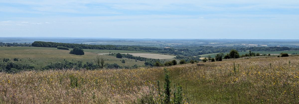
<p>Today’s intention was to have my first go at the RSGB 144MHz Backpackers contest, and conveniently get a 2m SSB SOTA activation in at the same time, since we’re now in summer and my 2m SSB contact count on SOTA peaks remains a big fat zero. Win Green was the obvious destination, an easy walk from the car and great VHF take-off in all directions.</p>

<p>But, as we pulled up to the car park, the first thing I spotted was… an antenna.</p>

<p>Someone else was already there.</p>

<p>We went over to say hi of course, and met some members of Salisbury Marconi Society, G5MAR hard at work on the contest. Hopefully we didn’t distract them too much, and had a nice chat. But of course with them operating from Win Green, we would have to find ourselves another hill to avoid causing them interference.</p>

<p>We did want to stick around the area though, because today was a <a href="https://www.comptonairfield.com/events/warbird-weekend-4/">Warbird Weekend</a> at Compton Abbas airfield, and the second goal of the day was to take some photos of the many vintage aircraft flying in and out.</p>

<p><img src="/img/blog/2026/06/backpackers-1.jpg" alt="Tiger Moth K-4259 in flight" class="center" /></p>

<p>Remembering <a href="/blog/145-alive-at-fontmell-down/">my previous 145 Alive 2m SSB operation from Fontmell Down</a>, we headed that way. But on arrival it reminded me why I specifically picked it, because it had great take-off… to the west, where the net controller for 145 Alive was. It was immediately clear today that to the north and east, the situation was pretty much a write-off, and that’s the directions where many of our contacts would be.</p>

<p>But temptingly visible to the right of the car park is a much higher spot—not quite high enough to be a SOTA peak, but definitely with great views all around: Melbury Beacon.</p>

<p>It looked pretty close.</p>

<p>2.4km of walk and 80m of elevation gain later (most of the elevation being in one hard slog at the end), we’d made it to the top and were rewarded with scenic views of Cranborne Chase and the town of Shaftesbury.</p>

<p><img src="/img/blog/2026/06/backpackers-2.jpg" alt="Shaftesbury viewed from Melbury Beacon" class="center" /></p>

<p>Somehow the civilised activations, the short walks from the car park, always turn into this kind of nonsense!</p>

<p>By this point however, it was gone 1030 UTC—an hour and a half of the four-hour contest had already passed, and it was definitely time to get on the air.</p>

<p>This was my first Backpackers contest, and I wasn’t sure how busy the bands would be. Things seemed pretty quiet to me, although some of my contacts were throwing around serial numbers in the 50s and above, so clearly they were having a lot more luck than I was.</p>

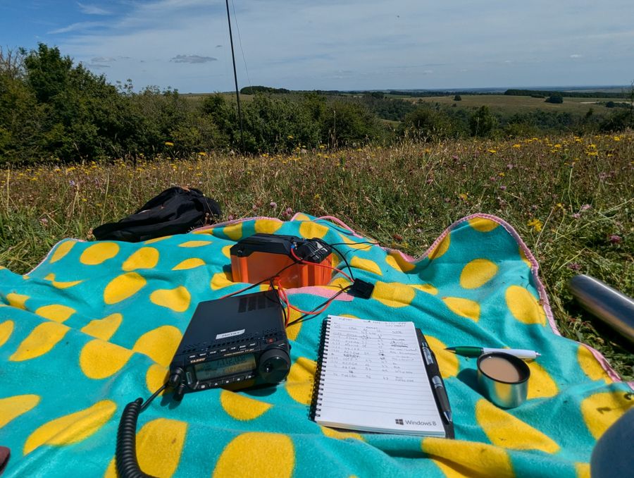
<p>The setup over at M5MAR certainly looked great, with a decent pole, 8-or-so element Yagi and three operators to share the logging duties. But up on Melbury Down, we very much had our “my first VHF contest” setup: 4-element Yagi on a camera tripod, only around head height. I was also logging for myself today, as my very tired logging assistant was more interested in plane photos and sleeping!</p>

<p>Nevertheless we persevered, getting seven contacts in the log by search-and-pounce. Then, a mysterious high noise floor seemed to appear across the band. Without any idea what was causing it, we decided that was a fine time to stop for lunch.</p>

<p><img src="/img/blog/2026/06/backpackers-3.jpg" alt="Me with my FT-817 handbag and antenna, making a QSO" class="center" /></p>

<p>The whole kit is in that bag, by the way: the FT-817 is in the main pocket, and the lower outside pocket containing an INIU USB power bank. The fist mic and my phone rest in the upper pocket, and the coax is routed out the top to the antenna.</p>

<p>After lunch I decided to call CQ for a bit, netting another 9 QSOs to bring the day’s total to 16. My best DX and only international contact was with EI3ENB/P on SOTA summit EI/IE-061; despite an opportunistically turning the beam around to the south, I didn’t manage any cross-Channel contacts.</p>

<p>While I’ll probably come last in the contest, I don’t think it was a bad first attempt. It’s already doubled the number of QSOs I’ve had on 2m SSB, even if they weren’t from a SOTA summit, and it’s renewed my excitement for future Backpackers contests where I can improve on my operating technique and maybe my equipment too.</p>

<p>But most importantly, we had a good time and a nice walk on a lovely Sunday afternoon.</p>

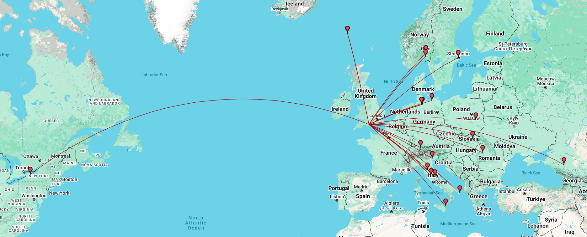
<div class="breakout-full-width"><center><img src="/img/blog/2026/06/backpackers-map.png" alt="QSO Map with callsigns and grid references shown" style="width:100%" /></center></div>

<p>Thanks to all my contacts today. Catch you on the air next time!</p>]]></content><author><name>Ian Renton</name></author><category term="blog" /><category term="ham-radio" /><category term="radio" /><category term="amateur-radio" /><category term="contest" /><summary type="html"><![CDATA[There was a hike. There's always a hike.]]></summary><media:thumbnail xmlns:media="http://search.yahoo.com/mrss/" url="https://ianrenton.com/img/blog/2026/06/backpackers-3-small.jpg" /><media:content medium="image" url="https://ianrenton.com/img/blog/2026/06/backpackers-3-small.jpg" xmlns:media="http://search.yahoo.com/mrss/" /></entry><entry><title type="html">Activation Report: The Heatwave Roves</title><link href="https://ianrenton.com/blog/activation-report-the-heatwave-roves/" rel="alternate" type="text/html" title="Activation Report: The Heatwave Roves" /><published>2026-05-26T00:00:00+00:00</published><updated>2026-05-26T00:00:00+00:00</updated><id>https://ianrenton.com/blog/activation-report-the-heatwave-roves</id><content type="html" xml:base="https://ianrenton.com/blog/activation-report-the-heatwave-roves/"><![CDATA[<p>Whitsun weekend, 2026. The country bakes under an unrelenting sun. Heat health warnings have been issued, with daily highs of 32C; the hottest May day since records began.</p>

<p>Alright, time for some parks!</p>

<h2 id="day-one-25th-may">Day One: 25th May</h2>

<p>On the first day, I tackled the four remaining parks of my challenge that were close to the edge of my 20-mile boundary, in a long arc from Wiltshire down into Hampshire.</p>

<p><img src="/img/blog/2026/05/rove-route.png" alt="Google Earth map showing all parks on day one" class="center" /></p>

<p>The parks are described below by their “primary” POTA references, the ones that I wanted to tick off my list, but the first two were in Cranborne Chase and the second two in the New Forest, providing a bonus POTA reference and a WWFF reference for each.</p>

<p>I also called “CQ Tiles” today. <a href="https://tilesontheair.com/">“Tiles on the Air”</a> is a new programme that has no fixed reference list, just your Maidenhead square, but is all about encouraging portable operation wherever and whenever. It gives bonus points for distance hiked and pack weight, so it’s right up my street! I’d encourage anyone interested to give it a go.</p>

<h3 id="0830-0930z-gb-6613-middleton-down">0830-0930Z: GB-6613 Middleton Down</h3>

<p>The easiest access to Middleton Down is from Ox Drove. You head down a series of increasingly small country roads (though all of them are at time of writing in a good state of repair), approaching from the west past the farm, until arriving at an inconspicuous gate. There’s space for a car on the verge here, and a few more spaces back up the road.</p>

<p><img src="/img/blog/2026/05/rove-route-1.png" alt="Google Earth map showing route into Middleton Down" class="center" /></p>

<p>Really, Middleton Down is peak POTA. It’s quite accessible, only 200m or so walk from a parking spot, has lots of open space for antennas and also plenty of trees to find shade under—a recurring theme of this rove.</p>

<p><img src="/img/blog/2026/05/rove-1.jpg" alt="Antenna at Middleton Down" class="center" /></p>

<p>This activation was my first Hare on the Air—no photos I’m afraid as he ran much too quick for me!</p>

<p>Another recurring theme of the day was feeling unusually blessed by the bands. I set up and found a free frequency on 40m immediately, so based on recent performance I assumed the worst; that the band was dead. But it was most certainly not, and after calling CQ only a couple of times, I had a pile-up of 44 QSOs in 30 minutes.</p>

<p>Equipment for all the Heatwave Rove spots was the FT-891 running at 100W from a 20Ah battery; this activation used the inverted-V dipole antenna and 6m SOTAbeams Tactical Mini pole.</p>

<p>The air temperature had started at 24C when I arrived on site, but when I got back to the car it was already 27, and pushing higher. By the time I reached my next destination, it had reached 30.</p>

<h3 id="0945-1230z-gb-6798-clearbury-down">0945-1230Z: GB-6798 Clearbury Down</h3>

<p>An all-time new one in the POTA system, I was a little put off by the fact the <a href="https://pota.app/#/park/GB-6798">POTA site’s page for this park</a> has a link to <em>Grokipedia</em>, of all things. I was quite prepared for Clearbury Down to be entirely fake, if not some sort of right-wing conspiracy. But other websites do mention it, including providing walking routes, and it turns out of course that it does exist.</p>

<p>The layby on the main Ringwood to Salisbury road is the ideal start point for this one, and after buying a couple of bottles of water from Josef’s Burger Van, I set off up the road. There’s 100m or so of busy roadside verge to deal with before you reach the start of the bridleway, heading west towards the Down.</p>

<p><img src="/img/blog/2026/05/rove-route-2.png" alt="Google Earth map showing route into Clearbury Down" class="center" /></p>

<p>A bit of Street View recon showed the entrance to the bridleway as steep and overgrown, so I took a bamboo cane with me in case I had to whack my way through the nettles. Luckily it wasn’t so bad in real life, and after a steep slope of 5 metres or so, I was past a narrow gate and out into the field. (Jury’s out on whether you could really get a horse up this alleged “bridleway”.)</p>

<p>From the road to Clearbury Down is about a mile hike up a slight incline all the way. It’s not in any way steep, but the return journey was noticeably easier going. It’s also significantly rutted from tractor tyres, so ankle support is recommended. (Because of the heat I had, of course, worn my breathable “trail” trainers rather than my decidedly not-breathable walking boots. Sucks to be me.)</p>

<p><img src="/img/blog/2026/05/rove-3.jpg" alt="Oxeye daisies on the path to Clearbury Down" class="center" /></p>

<p>At this time of year the oxeye daisies are in full bloom around the hedgerows and corners of the fields. I’m not sure why, but there seem to be so many more of them this year than in years past. I also scored my first Partridge on the Air on the hike up.</p>

<p>Clearbury Down is capped by an Iron Age hill fort, WCA G-03856. Unfortunately the gates by which you could enter the area were locked shut, so I headed around to the south and up to the gate that divides the farmer’s field from the Down itself. By this point I was pretty exhausted from the heat, so I didn’t spend much time exploring, and just set up immediately in the shade of the closest tree.</p>

<p><img src="/img/blog/2026/05/rove-2.jpg" alt="Antenna at Clearbury Down" class="center" /></p>

<p>Again the bands were unusually kind, with my previous frequency still clear. The pile-up got going immediately, and I rattled through 66 QSOs in 54 minutes before I’d spoken to everyone I could, and it was time for the long walk back.</p>

<p>In today’s 30C heat, I got through just under a litre of water in this hike, so I would recommend anyone following in my footsteps to take at least that much. It’s not a long or tough hike by any means, but in weather this hot it takes it out of you.</p>

<h3 id="1300-1330z-gb-6799-franchises-wood">1300-1330Z: GB-6799 Franchises Wood</h3>

<p>Next on the hit list was Franchises Wood. <a href="https://group.rspb.org.uk/southwiltshire/local-wild-places/rspb-franchises-wood/">Its website</a> is a bit unclear about whether it’s really “open” in an “RSPB site” sense, but with several public rights of way crossing it, I figured I would head in anyway and see what antenna opportunities presented themselves.</p>

<p>Since the site claimed not to have a car park, I parked just across the road at—where else—Telegraph Hill car park, and prepared myself for some tele<strike>graphy</strike>phony.</p>

<p>Telegraph Hill, incidentally, is the highest point in the gently rolling New Forest. It was the site of the Napoleonic era Bramshaw Telegraph Station, a link in the chain from London to Plymouth. This was an optical shutter telegraph station, so not involving electrical or radio telegraphy, but it’s a nice piece of history nonetheless. Unfortunately nothing remains of the site, and I don’t believe it is marked.</p>

<p><img src="/img/blog/2026/05/rove-route-3.png" alt="Google Earth map showing route into Franchises Wood" class="center" /></p>

<p>The site itself is thickly wooded and largely down in a deep valley, which would be great to explore but not so great for RF getting out to the ionosphere. Luckily, just inside the main by-way on the right-hand side is what looks awfully like… a (very overgrown) car park.</p>

<p>It had a low chain fence to prevent anyone driving in, but nothing implied that <em>people</em> weren’t welcome, so I decided to do the activation from there. It was shaded from the south as well, which helped a lot as by this point the temperature had reached the day’s high of 32C.</p>

<p><img src="/img/blog/2026/05/rove-4.jpg" alt="Antenna at Franchises Wood" class="center" /></p>

<p>This time I packed the JPC-12 antenna since I knew space would be tight, and luckily the tripod too, since the car park surface certainly wouldn’t have supported a ground spike.</p>

<p>As I had the JPC-12 I decided to make this my first (and, it turns out, only) 20m activation of the day. I’d hinted in my POTA alerts that I’d do 40 <em>and/or</em> 20 at the other spots, but in the end the pile-up on 40m had been so big that I’d run out of time for any other bands. Here, without access to 40m in any useful way, it would have to be 20.</p>

<p>I called CQ, and noticed the song of a nearby blackbird for the first time: we had synced up, my “CQ” and its two-tone call.</p>

<p>20m was definitely a quieter band, but I still rattled through 24 QSOs in 20 minutes. This being a rove, as soon as the calls dried up, it was “QRT” and on to the next one.</p>

<h3 id="1400-1530z-gb-6800-copythorne-common">1400-1530Z: GB-6800 Copythorne Common</h3>

<p>I wasn’t sure where to park for this one. I picked the lay-by by the school to the south of the site, although I noticed on returning to the car that it’s signposted as “parking on school business only”. (Good thing it’s a bank holiday.) There are some suburban roads to the north-east of the site that probably make a better entry point. But here’s my route:</p>

<p><img src="/img/blog/2026/05/rove-route-4.png" alt="Google Earth map showing route into Copythorne Common" class="center" /></p>

<p>From my starting point, it was first over the motorway, and then immediately right through the gate. Despite the western end of the park being nominally woodland and the eastern being open heath, there’s much more open space to the west. Take the northern forks of each path and you’ll soon end up at a huge open grassy space. (Or, like me, you could discover this <em>after</em> activating in the middle of the heath section, and after wandering for 30 minutes to find enough space there for the dipole.)</p>

<p><img src="/img/blog/2026/05/rove-6.jpg" alt="Clear area among the trees at Copythorne Common" class="center" /></p>

<p>My elaborate route did allow me to hear a song thrush in the trees, so that was a bonus.</p>

<p>Again I had hoped to operate on both 40m and 20m here, but time and the pile-up got the better of me. Once again I found a clear frequency on 40m immediately, and got a pile-up from the very first “CQ”. (This park was another all-time new one in the POTA system, which probably helped.)</p>

<p>An hour and 64 QSOs later, I was fast running out of time, and sadly on this one I couldn’t even make it to the end of the 40m pile-up. I sadly called “QRT”, packed up, and headed out.</p>

<p><img src="/img/blog/2026/05/rove-5.jpg" alt="Antenna at Copythorne Common" class="center" /></p>

<p>In total on the day one I made 198 QSOs, 174 on the 40m band and 24 on 20m; I walked 4.6 miles and took 10900 steps, got through just under two litres of water and 500ml of tea.</p>

<p>And as always I’m immensely glad that what others think of as a holiday destination, I know as home. <em>I</em> had a nice easy 30 minute drive back down the dual-carriageway towards Dorset. The tourists, heading home after their weekend at the seaside… not so much:</p>

<p><img src="/img/blog/2026/05/rove-traffic.png" alt="Traffic map, showing a huge tailback heading away from Dorset" class="center" /></p>

<h2 id="day-two-26th-may">Day Two: 26th May</h2>

<p>Day two covered the three remaining local parks that I hadn’t yet activated (excluding the one it’s currently not possible to activate). This was a much more laid-back day: no significant hikes, and not straying far from civilisation.</p>

<h3 id="1015-1045z-gb-6871-stanpit-rec">1015-1045Z: GB-6871 Stanpit Rec</h3>

<p>Nice and simple: park in the free car park, head out into the middle of the field, and set up. The hard-packed ground today wouldn’t support pegs or ground spikes, so I was left with the JPC-12 and its tripod base again.</p>

<p><img src="/img/blog/2026/05/rove-7.jpg" alt="Antenna at Stanpit Rec" class="center" /></p>

<p>Luckily, the 20m band was popping this morning, and despite it being a normal working day in most countries, I didn’t struggle for contacts. In fact it was so well open that I exchanged 58 (sent) and 55 (received) reports with Rich VE9RK over in New Brunswick, Canada. I had calls from VE1SK, KB1HNZ and N2IGW as well, for a total of four transatlantic contacts. I also had a QSO with Mehmet TA4YMA in Turkey, a country I often struggle to get in the log.</p>

<h3 id="1115-1145z-gb-6879-iford-playing-fields">1115-1145Z: GB-6879 Iford Playing Fields</h3>

<p>Another new addition to the POTA system; I did neighbouring <a href="/blog/pota-activation-report-iford-meadows/">Iford Meadows</a> way back at the start of last year, but the adjacent playing fields have now been added as their own reference.</p>

<p>Once again the temperature was starting to hit 30C in the middle of the day, but unlike the wide open field at Stanpit Rec, there are some trees here to provide shade.</p>

<p><img src="/img/blog/2026/05/rove-8.jpg" alt="Antenna at Iford Playing Fields" class="center" /></p>

<p>I had three more transatlantic QSOs here, with K3BOA as well as regular POTA hunters K2UPD and W1OW. After 12 QSOs in 15 minutes or so, things started to tail off, and since I was getting hungry I figured that was a suitable point to head off for lunch.</p>

<h3 id="1230-1500z-gb-6769-happy-bottom">1230-1500Z: GB-6769 Happy Bottom</h3>

<p>Yep, it’s called Happy Bottom. You can make your own jokes. It’s also park reference six-seven sixty-nine, in case you want to factor that in.</p>

<p><img src="/img/blog/2026/05/rove-9.jpg" alt="Happy Bottom sign" class="center" /></p>

<p>Much like Copythorne Common, I did a lot more wandering around here than I should have done, and activators heading here should avoid following too closely in my footsteps! The lay-by where I parked on Merley Park Road is the best starting point, but I chose to head down Roman Road into the woods. This part of Happy Bottom is thickly wooded with no good antenna sites. It took half an hour of wandering, out of the site through the farm to the north-east, back to the road, and finally on the southern route through the park before I found a grassy field to activate from.</p>

<p>Only after my activation, whilst doing a recce for club members looking to activate tomorrow, did I discover the biggest open field (which it turns out, they already knew about), known as Colin’s Meadow. If I’d passed by Roman Road and walked just 50 metres up Merley Park Road, I’d have discovered it immediately, and saved a good half hour of stomping around.</p>

<p>There were no transatlantic contacts here, but not for want of trying—fedi mutual Alex KR1ST was calling but we could not hear each other. I did have two contacts with local club members Seb M9SEB and Richard M0RHS on groundwave though, and discussed their plans to activate the site the very next day!</p>

<p>With 11 in the log after 15 minutes, I decided to cut the activation short. It was just too warm out there, and without much shade, I was really feeling the heat. It was time to head back to the car and be very grateful for its A/C!</p>

<p>Here’s the map of all contacts on this two-day rove:</p>

<div class="breakout-full-width"><center><img src="/img/blog/2026/05/rove-map.png" alt="Activation map" style="width:100%" /></center></div>

<p>And here’s the detail of some of the 40m contacts:</p>

<div class="breakout-full-width"><center><img src="/img/blog/2026/05/rove-map-2.png" alt="Activation map" style="width:100%" /></center></div>

<p>For my challenge to activate all parks within 20 miles of home, that’s now 137 done—and just one remaining. <em>It doesn’t open until July</em>. Let’s hope the local POTA activators or country reps are taking pity on me, and don’t add too many more parks in the next month…</p>

<p>Thanks to all my contacts across the last two days. Catch you on the air next time!</p>]]></content><author><name>Ian Renton</name></author><category term="blog" /><category term="ham-radio" /><category term="radio" /><category term="amateur-radio" /><category term="pota" /><category term="rove" /><summary type="html"><![CDATA[Seven sweltering pile-ups (it's better than it sounds)]]></summary><media:thumbnail xmlns:media="http://search.yahoo.com/mrss/" url="https://ianrenton.com/img/blog/2026/05/rove-3-small.jpg" /><media:content medium="image" url="https://ianrenton.com/img/blog/2026/05/rove-3-small.jpg" xmlns:media="http://search.yahoo.com/mrss/" /></entry><entry><title type="html">Plane/Sailing v5 Changes</title><link href="https://ianrenton.com/projects/planesailing/plane-sailing-v5-changes/" rel="alternate" type="text/html" title="Plane/Sailing v5 Changes" /><published>2026-05-23T00:00:00+00:00</published><updated>2026-05-23T00:00:00+00:00</updated><id>https://ianrenton.com/projects/planesailing/plane-sailing-v5-changes</id><content type="html" xml:base="https://ianrenton.com/projects/planesailing/plane-sailing-v5-changes/"><![CDATA[<p>This page lists the differences between version 4 of Plane/Sailing, with a Java-based server, and version 5, which rewrote the backend code in Python. My intention is to keep the main build guide up-to-date with the latest state of the system, as this will be of most interest to readers, while maintaining pages like this one to explain what’s changed for returning visitors.</p>

<p><img src="/img/projects/planesailing/ui5.png" alt="Plane/Sailing v5 Interface" class="center" />
<em>Plane/Sailing v5.0</em></p>

<p>After a couple of years of writing only Python and JS projects in my spare time, and a couple of emails from users struggling to get the Java dependencies and compilation going, I decided to rewrite the back-end of Plane/Sailing in Python.</p>

<p>This also allowed me to take advantage of the slightly better features of the third-party libraries for decoding ADS-B, AIS and APRS on the Python platform. Being a more common choice for hobby developers does seem to mean that the library ecosystem is a little better for this kind of stuff.</p>

<p>Aside from a couple of layout tweaks, the user-facing front end didn’t change between Plane/Sailing 4 and 5, and functionality shouldn’t be impacted.</p>

<p>The README has of course been fully updated with the new set of instructions to get the system up and running.</p>]]></content><author><name>Ian Renton</name></author><category term="projects" /><category term="planesailing" /><summary type="html"><![CDATA[This page lists the differences between version 4 of Plane/Sailing, with a Java-based server, and version 5, which rewrote the backend code in Python. My intention is to keep the main build guide up-to-date with the latest state of the system, as this will be of most interest to readers, while maintaining pages like this one to explain what’s changed for returning visitors.]]></summary></entry><entry><title type="html">POTA Rove Report: The Meeting of the Ways</title><link href="https://ianrenton.com/blog/pota-rove-report-the-meeting-of-the-ways/" rel="alternate" type="text/html" title="POTA Rove Report: The Meeting of the Ways" /><published>2026-05-05T00:00:00+00:00</published><updated>2026-05-05T00:00:00+00:00</updated><id>https://ianrenton.com/blog/pota-rove-report-the-meeting-of-the-ways</id><content type="html" xml:base="https://ianrenton.com/blog/pota-rove-report-the-meeting-of-the-ways/"><![CDATA[<p>My part of the world is home to two major rivers, the Stour and the Avon, which both meet each other and the sea at Christchurch. Both have trails along their length that have been recently added to the POTA system, as has the Castleman Trailway, which crosses them both. And so, I decided a nice idea for a quick POTA rove would be to activate these meeting spots one after another.</p>

<h3 id="0900-0930z-avon-valley-path--castleman-trailway">0900-0930Z: Avon Valley Path / Castleman Trailway</h3>

<p>Both <a href="https://pota.app/#/park/GB-6372">GB-6372 Avon Valley Path</a> &amp; <a href="https://pota.app/#/park/GB-6370">GB-6370 Castleman Trailway</a> are extensive trails that could be activated just about anywhere along them. The <a href="https://www.dorsetcouncil.gov.uk/w/castleman-trailway">Castleman Trailway</a> is part of what remains of the old Dorchester-to-Southampton railway, running from Upton House in the west, into the New Forest in the east. The Avon Valley Trail is even longer, running from Salisbury in the north to Mudeford in the south, including a number of villages on the way (a liberal reading of the POTA rules may allow you to activate it from the beer garden of the Woolpack Inn).</p>

<p>The POTA requirement for “trail” type parks is that your entire station must be within 30 metres of the trail, which can make things difficult by itself. But if I wanted to activate them both at their sole meeting spot, I would have an area of just 30x30m square in which to set up. And keeping the public out of RADHAZ range means any radiating element being around 6 metres away at minimum, reducing that area in effect to 24x24m.</p>

<p>These two paths intersect <a href="https://maps.app.goo.gl/9Emm5mdvujeXqUtg8">here</a>, at this fairly uninspiring spot outside Ringwood:</p>

<p><img src="/img/blog/2026/05/castleman-1.jpg" alt="Two crossing paths" class="center" /></p>

<p>This area is busy with walkers, and setting up directly next to the trail was a non-starter. I was planning on going for the open grassland to the south of the Castleman Trailway, which the Avon Valley Path cuts through, but on arrival it did not look much like common land—instead, there were grazing cattle and horses, and it looked very much like a public right of way through private farmland. As always, “right of way” means to walk, sometimes to cycle, very rarely to set up an amateur radio station!</p>

<p>Happily, just north of the intersection, there is a small gravel area next to the river, with just enough space for the JPC-12 vertical, though not for any large dipole antennas.</p>

<p><img src="/img/blog/2026/05/castleman-2.jpg" alt="Two crossing paths" class="center" /></p>

<p>I set up here, and although the bands weren’t in great shape, I made 11 contacts in around half an hour, including John G4POF from the local club via ground-wave. All contacts were made using 100W on the 20m band using the Yaesu FT-891.</p>

<p>It’s about nine miles from this spot to the point the Stour Valley Way crosses the Castleman Trailway, so in the interests of time, I drove around to my second spot today. It would make a nice, if unexciting, cycle; probably too far for a walk if you had to walk back to the other end again too!</p>

<h3 id="1030-1130z-stour-valley-way--castleman-trailway">1030-1130Z: Stour Valley Way / Castleman Trailway</h3>

<p>Compared to the uninspiring meeting of the Castleman Trailway with the Avon Valley Path, its meeting with the <a href="https://www.dorsetcouncil.gov.uk/w/stour-valley-way">Stour Valley Way</a> is this impressive structure: Lady Wimborne’s Bridge.</p>

<p><img src="/img/blog/2026/05/castleman-3.jpg" alt="Large imposing stone bridge over a path" class="center" /></p>

<p><a href="https://pota.app/#/park/GB-6830">GB-6830 Stour Valley Way</a> has been on the POTA system since <em>yesterday</em>, and yet somehow I am the <em>fourth</em> activator. I share the leaderboard with <em>exactly</em> who I thought I’d be sharing it with: Ingy M0MHJ, John M6EAM and Roger G5RWM.</p>

<p>The Stour Valley Way in its entirety is the longest trek of them all, starting with the Stour at Mere in Wiltshire, passing through many other POTA parks and scenic spots, and winding its way down to the sea at Christchurch. By my reckoning I would have activated it seven times already if it were in the POTA system since the start!</p>

<p>There’s some space at the bottom of the bridge for an antenna, but this was thickly carpeted with nettles, and in any case I didn’t want a giant wall of stone between me and my contacts, so I headed to the top. With a narrow path and thick woods either side on the Castleman Trailway (top) side, the only real open space here is directly on top of the bridge, so… that would have to do.</p>

<p>Then, the comedy of errors began.</p>

<p>I hadn’t brought my tripod with me, so all I had available to keep the antenna upright was the ground spike—not too effective on top of a stone bridge, although plants were encroaching on it so there were a few centimetres of soil in places. After a few attempts to get the ground spike in, I gave up, and decided the antenna would have to be propped up against something. Then, having put the rest of the antenna together, it occurred to me: where was the whip?</p>

<p>Unknown to me until the end of the activation, the ground spike I’d been trying to shove into any available soil… <em>was</em> the whip. How I didn’t spot that I have no idea. As to where the ground spike went to, I’m not sure—I retraced my steps in case it fell out of my bag but couldn’t find it, so perhaps I accidentally left it at my first spot. I will need to revisit at some point to find out.</p>

<p>So, I sort-of had a ground spike (the whip that I had now broken beyond recovery by stabbing it into the ground), but no main radiating element. The activation attempt was over before it had even begun.</p>

<p>…</p>

<p>But I did have <em>three</em> ground radials. Probably didn’t need <em>three</em>, right?</p>

<p>Time to Heath Robinson an antenna. (Substitute “MacGuyver” as necessary depending on your age and nationality.)</p>

<p><img src="/img/blog/2026/05/castleman-antenna.jpg" alt="Antenna &quot;design&quot;" class="center" /></p>

<p>While the JPC-12 is very flexible and allows a variety of ways to combine its sections, I bet today was the first time <em>this one</em> has been tried.</p>

<p>Vertical section #4 was doing double duty here, both allowing the antenna to rest on a convenient bramble, and clamping the radiating wire down into the top of the coil. With zero turns on the coil (slider at the top) I managed a 2:1 SWR, and with some rearranging of how the wire was hanging in the tree, I eventually managed pretty well a spot-on 1:1 SWR.</p>

<p>As we all know though, SWR isn’t everything (a 50 Ohm dummy load has perfect SWR after all), and this setup was… trash. Poor band conditions didn’t help today, but <em>oh boy</em> was it hard work making contacts.</p>

<p><img src="/img/blog/2026/05/castleman-4.jpg" alt="Antenna loading coil resting in tree" class="center" /></p>

<p>It took over ten minutes to get my first contact. Hilariously at that point, the main body of my antenna fell down, and I <em>immediately</em> received a call from K2UPD in which he gave me a 54 report. Did this antenna genuinely work better with the main bit <em>on the floor</em>?!</p>

<p>You’ve heard of “inverted L” antennas, now try “actual L” antennas, just leave the radiator running along the ground, probably fine??</p>

<p>I spent the rest of the activation playing with the antenna and the layout of my two remaining ground radials, hoping for some improvement in performance, but contacts were slow coming and I rarely received or gave a report above S5. My transatlantic fluke was not repeated, but in the end a variety of hunters around Europe got me over the line after an hour on the air.</p>

<p><img src="/img/blog/2026/05/castleman-map.png" alt="Activation map" class="center" /></p>

<p>Thanks to all my contacts today, especially those that struggled to make it work at the second activation spot. I’m off to order a new whip for this thing, catch you on the air next time!</p>]]></content><author><name>Ian Renton</name></author><category term="blog" /><category term="ham-radio" /><category term="radio" /><category term="amateur-radio" /><category term="pota" /><category term="rove" /><summary type="html"><![CDATA[Terrible band conditions, marginal success, only broke a few things!]]></summary><media:thumbnail xmlns:media="http://search.yahoo.com/mrss/" url="https://ianrenton.com/img/blog/2026/05/castleman-3-small.jpg" /><media:content medium="image" url="https://ianrenton.com/img/blog/2026/05/castleman-3-small.jpg" xmlns:media="http://search.yahoo.com/mrss/" /></entry></feed>