"Two roads diverged in a wood, and I—
I took the one less traveled by,
It basically looped back on itself and it was quite muddy.
Probably should have stuck with the road all those other folks took."
—Robert Frost, POTA Activator (probably)
It’s October, out on the heath. The days start cold now, with a damp chill in the air that the weak sunshine never quite manages to break through.
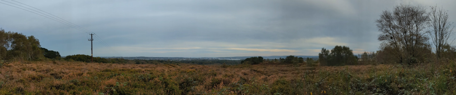
This is Upton Heath, POTA ref GB-0112, WWFF ref GFF-0315. This area of heathland is managed by Dorset Wildlife Trust, and while much of it is natural heathland just as it always was, the marks of human use are all over. The heath is criss-crossed with electricity pylons, and the noise of the main road can be heard everywhere. Houses are slowly encroaching, always out of the corner of your eye.
But some relics of human occupation are receding. The Southampton and Dorchester Railway ran through here once, from the mid-1800s until it was torn up in the Beeching cuts in the 1960s; much its route now forms the scenic Castleman trailway. The former brick works have gone too, now long since demolished, though the scars on the land left by their excavations remain.
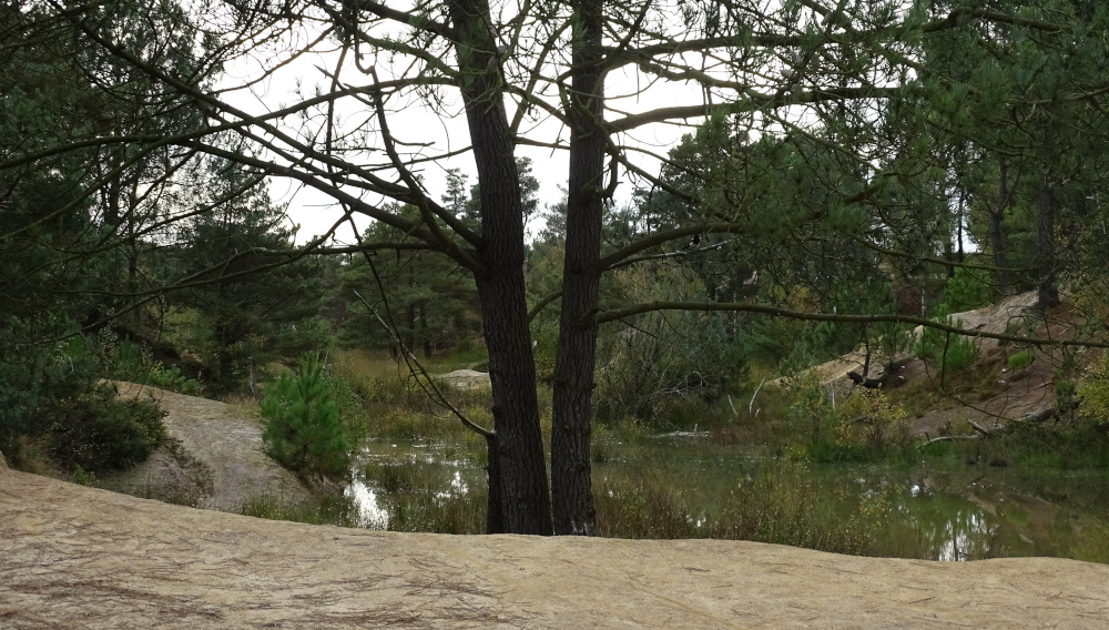 Former clay pits on Upton Heath
As well as a good place to get lost in, I had some extra goals for today’s POTA/WWFF activation: to give my new antenna its first proper shake-down, to give Field Spotter its first run at what it was meant to be used for, and to have a go at logging with Ham2k PoLo rather than my usual paper logs.
I took the NanoVNA to help get the tuning right for the antenna, which is extra hassle and bag space consumption that I could do without. However, as my first time in the field with a new vertical antenna, it proved essential and I managed to get nearly 1:1 SWR in the 20m band. My attempt at tuning it for 40m was not so successful unfortunately, so I stayed on 20 throughout the activation.
As well as needing the VNA, the rest of the new antenna kit brought a new challenge in the form of pack weight. With the bulkier kit and the totally overkill LMR240 coax, my rucksack was fast approaching 10kg, and no longer had any real amount of free space inside for a coat or any other equipment.
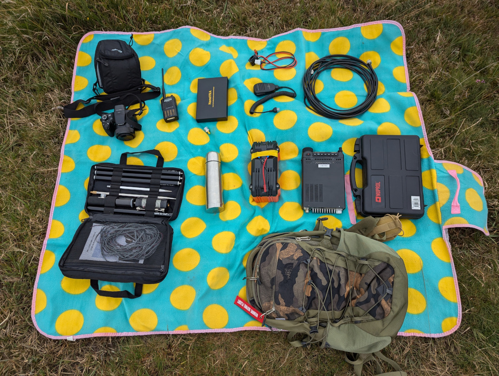 My rucksack and contents laid out on the ground
Nothing makes you look quite as extra as boots, thermos, and a 10kg camo-coloured rucksack with an HT strapped to it, while everyone else is walking their dogs and wearing trainers.
PoLo worked well, though it took a few park-to-park contacts before I figured out where to put the other party’s park reference. I do particularly like the integrated spots list, which while it doesn’t quite replicate the visual interface we have in Field Spotter, it does at least check off people you have already spoken to—a nice feature to have when the log gets long enough that you start forgetting.
Field Spotter worked fine as expected, too. It’s nice to have finally used it in the environment it was intended for!
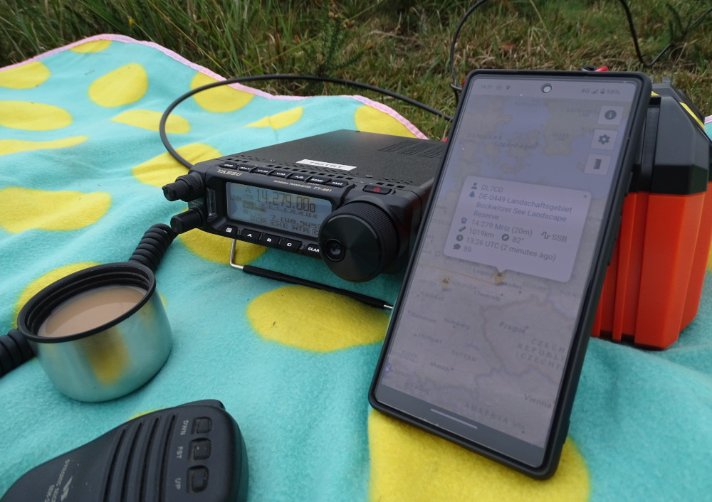 Field Spotter in use in the field
With plenty of new things to test, I kept the activation itself pretty basic. I started off with Field Spotter giving me a few park-to-park QSOs, then I settled into a frequency of my own and called CQ. The pile-up delivered as usual, and after getting around 30 in the log in just over half an hour, I decided to pack down the station and do a bit more exploring down towards the clay pits and the lake.
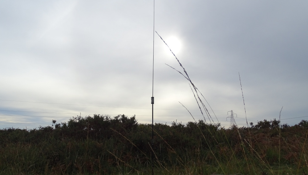 JPC-12 antenna with loading coil silhouetted against the sky
There are plenty of opportunities to get lost here; paths that look like shortcuts but just loop around, and ones that peter out into gorse and mud. The “proper” path zig-zags wildly and dips up and down, and is not always obvious. Google Maps doesn’t know most of the paths here either, so taking a photo of the map board or using an OpenStreetMap-based app is definitely recommended for navigation.
An hour of wandering passed, but the sun never did burn through the clouds. A pale and slowly fading light signalled the end of the day, and with a kilometer hike and 50m of elevation gain ahead of me, I turned and headed for the car.
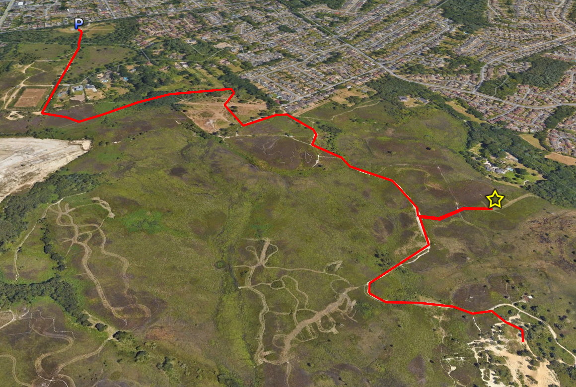 Walking route to and from the activation spot
Thanks to all my contacts today:
| UTC | Frequency | Callsign | RST Sent | RST Rcvd | Name | Park |
|---|---|---|---|---|---|---|
| 1335 | 14.279 | DL7CD | 57 | 59 | Marcus | DE-0449 |
| 1349 | 14.320 | DL9TU | 59 | 59 | Uwe | |
| 1350 | 14.320 | F5PYI | 59 | 59 | Larry | |
| 1351 | 14.320 | 9A4MZ | 44 | 59 | Zeljko | |
| 1352 | 14.320 | OH3GZ | 53 | 57 | Jack | |
| 1353 | 14.320 | DL6APM | 57 | 57 | Pawel | |
| 1354 | 14.320 | EA3IDY | 49 | 59 | Jose | |
| 1355 | 14.320 | IU8CNE | 59 | 55 | Luca | |
| 1357 | 14.320 | EA1BUL | 59 | 57 | Jose | |
| 1357 | 14.320 | DG3DJ | 57 | 57 | Andreas | |
| 1358 | 14.320 | IZ2BKA | 49 | 57 | Giorgio | |
| 1358 | 14.320 | IW0HK | 59 | 59 | Borgnino | IT-0530 |
| 1359 | 14.320 | HB9HZC | 55 | 58 | Pat | |
| 1400 | 14.320 | DM5XT | 57 | 58 | Falko | DE-0860 |
| 1401 | 14.320 | DK5UR | 56 | 57 | Heinz | |
| 1402 | 14.320 | M7PHG/P | 57 | 57 | Seb | GB-0008 |
| 1403 | 14.320 | SP2EL | 45 | 59 | Arek | |
| 1404 | 14.320 | IU4QRU | 45 | 55 | Gian | IT-0918 |
| 1405 | 14.320 | IN3JIO | 59 | 55 | Davide | |
| 1405 | 14.320 | SM3NRY | 58 | 55 | Thomas | |
| 1406 | 14.320 | SP1C | 59 | 56 | Jarek | |
| 1407 | 14.320 | F4ILH | 43 | 53 | Jean | |
| 1407 | 14.320 | HB9HGW | 55 | 56 | René | |
| 1408 | 14.320 | F4LRR | 42 | 59 | Fab | |
| 1409 | 14.320 | DL7PIP | 57 | 59 | Sven | |
| 1410 | 14.320 | YO3GND | 31 | 41 | Richard | |
| 1411 | 14.320 | HB9HDI | 59 | 59 | Martin | |
| 1411 | 14.320 | DL2DXA | 55 | 56 | Bernd | |
| 1413 | 14.320 | F4LMS | 45 | 59 | Quentin | |
| 1414 | 14.320 | OM6IN | 57 | 59 | Lubomir | |
| 1423 | 14.320 | IQ7AF | 54 | 59 | A. R. Italiani Sezione di Lecce | |
| 1428 | 14.335 | HB9HCS/P | 42 | 55 | Stefan | |
| 1432 | 14.345 | EA5W | 57 | 59 | Paco | ES-1430 |
| 1445 | 14.310 | IZ0FTS/P | 54 | 54 | Daniele | IT-1838 |
…and this guy, thanks for the spot on the 500 nanometre band.
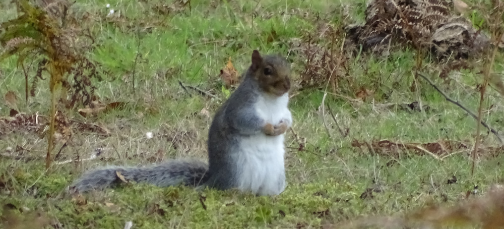 A grey squirrel on Upton Heath
Here’s the map from today:
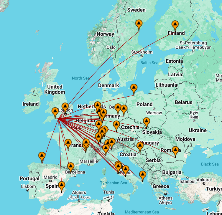 Map of contacts from the activation
See you on the air next time!
Comments